The Constantine Palaeologos Research Fund's generosity has enabled Rob Ixer and Richard Bevins to further elucidate the types of stones at Stonehenge in the current edition of WAHNS - an article for serious Stonehenge Geeks only.
Volcanic Group A Debitage: its Description and Distribution within the Stonehenge Landscape
by Rob A. Ixer and Richard E. Bevins
Abstract: The three major groups of debitage found in the Stonehenge Landscape are dolerites, rhyolitic tuffs (almost exclusively from Craig Rhosyfelin) and ‘volcanics with sub-planar texture’. This last group comprises two separate lithological sub- groups namely, Volcanic Group A, friable rocks with abundant white mica and a strong metamorphic fabric, and very rare Volcanic Group B hard rocks that are characterised partially by an unusual mineralogy including graphitising carbon. Petrography, whole rock X-ray diffraction and whole rock geochemistry suggest that Volcanic Group A is a coherent group representing a single lithology, namely an argillaceous lithic tuff and that it is quite different from Volcanic Group B (including Stonehenge orthostat SH38) and from Stonehenge orthostat SH40. Spatially, as with the other major debitage groups, Volcanic Group A lithics are widely and randomly distributed throughout the Stonehenge Landscape; temporally, almost none of the debitage has a secure Neolithic context. The debitage cannot be matched to any above-ground Stonehenge orthostat but may be from one or more of five buried and, as yet, unsampled stumps. The lithology is believed to be from an unrecognised source on the northern slopes of the Preseli Hills but perhaps not from Foel Drygarn as has been suggested
Saturday, 30 July 2016
Friday, 29 July 2016
Stonehenge Visitor Centre Wins Architectural Award
"That the modern world is not all high-tech bling is well demonstrated by the busloads of fast-food splattered gawkers who descend on Stonehenge; 1 million per year. The Visitor Centre feels Australian; in its basic partie it is a decoy, but also a sheep-pen and wool shed to shear the visitor flock of their spare change while dispensing a basic understanding of where and why they are there"
Peter Wilson Affiliate RAIA, Jury Chair
(I thought I noted this before but when I was in the employ of English Heritage they were happy to have received the award but less keen on their customers being described as "fast-food splattered gawkers" and the building to be described as "a sheep-pen and wool shed to shear the visitor flock of their spare change".
I thought the disdain shown was rather informative of the attitudes of the designer class.
Soures: WINNER 2014: JØRN UTZON AWARD FOR INTERNATIONAL ARCHITECTURE – STONEHENGE EXHIBITION + VISITOR CENTRE BY DCM
(As an aside his use of the term "partie" is as written - I presume he means the ""parti pris," usually shortened to "parti" I'm not sure if the extra "e" is an Oz affectation, they seem to add vowels to all sort of words - arvo, dunny, barbie - or maybe he was just overreaching in his attempt to sound sophisticated.
Tuesday, 26 July 2016
A Fourth Mesolithic Post Hole in The Stonehenge Car Park?
The old carpark at Stonehenge is famous for having three Mesolithic post holes discovered in 1966 (there was another pit marker WA9580 of probable similar age but with recuts in it)
During the relandscaping of the carpark following its closure a trench was dug just to the north of the 1966 excavations and just south of the fence line in the aerial photograph.
At position D (in the aerial photograph - click to enlarge any picture) I noticed the trench had cut through a soil anomaly that to my untrained eye looked very like another post hole. The northern section was very clear but the southern section had modern disturbance and rubbish in the top.
Despite asking I was never given any information about this or the periglacial stripes uncovered and no excavation report seems to be forthcoming so I place these photos here in the public interest.

(Cleal, R. M. J., Walker, K. E. and Montague, R., 1995, Stonehenge in its landscape: Twentieth century excavations English Heritage Archaeological Report 10)

(Google maps annotated by T C Daw)
Spot marked D is the unreported disturbance spotted in a trench during the restoration of the carpark to grassland.

The north side - yellow and black markers are the standard plastic path used at Stonehenge - I need to recheck size, my notes are that they are 150mm long.
Larger photos:

The north side - larger version

The south side

Position of mark with regard to fence and gateway

G and Vatcher, F 1973 Excavation of three post-holes in Stonehenge car park, Wiltshire Archaeological and History Magazine 68, 57-63
AUGUST 2025 Update - I discovered the record of a soakaway having been dug near this fourth pit, if the mapping is correct it is NOT this pit - the soakaway is in a bright green square in the plan and the overlay comparing it to Pit D - The soakaway can be seen in the trench as well near the fallen pedestrian barrier.
Details see: https://reports.cotswoldarchaeology.co.uk/wp/content/uploads/2014/07/2142-Stonehenge-Car-Park-WB-06035-complete.pdf


Click any picture to embiggen.
All the photos:


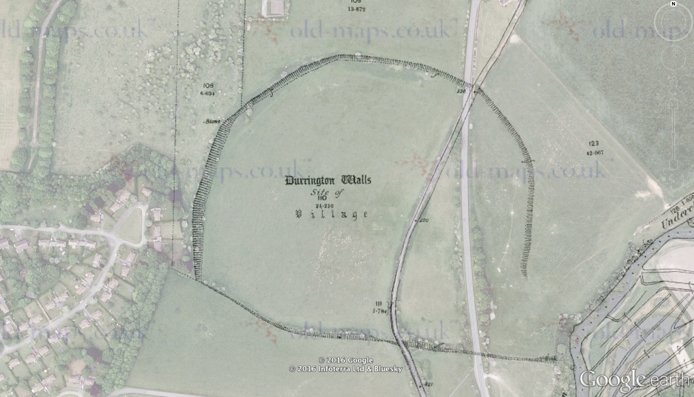
Sarsen Stone Found Buried Under the Bank of Durrington Walls
With the excavations at Durrington Walls starting in next week to discover if there is a row of buried stones under the bank, the so called Superhenge, or whether the geophysical anomalies are just chalk platforms, or something completely different, I have taken the liberty of reproducing the information that Simon Banton, the renowned expert on Stonehenge and its Landscape, has produced on his site mapping the barrows of the area about a sarsen stone that was found under the bank of Durrington Walls.


Durrington Flat Grave
AM: Flat grave with primary inhumation in cist covered by a sarcen with a flint dagger, whetstone, cone and belt ring of shale and two flint discs. Note: Location is not certain. PS: An inhumation in a grave covered by a sarsen boulder was found "above Durrington Walls" prior to 1812 (in which year Colt Hoare wrote that it had been discovered "lately" by a shepherd). The skeleton was accompanied by a flint dagger, a polished stone plaque or whetstone, a shale pulley ring, and a v-perforated shale button. These items, along with two discs of chalk, are in Devizes Museum. It has been suggested that the burial had originally been covered by a barrow, since ploughed out, although there is no trace of one either on the ground or from the air.
RCH: Durrington Walls (page 172)
RCH: In the rudest times other modes of burial, besides the barrow, were adopted. We have an interesting proof in an interment which was lately discovered above Durrington Walls, by a shepherd, who in pitching the fold, found his iron bar impeded in the ground : curiosity led him to explore the cause, which proved to be a large sarsen stone, covering the interment of a skeleton, with whose remains the articles engraved in TUMULI Plate XIX, were deposited, viz. a spear head chipped from a flint, a small hone or whetstone, a cone and ring of jet like a pully, and two little buttons of marl or chalk, all bespeaking an interment of the earliest date.
Historic England Monument Number: 219636
NMR Number: SU 14 SW 72
Wiltshire and Swindon Historic Environment Record: MWI12619 - SU14SW560
Wiltshire Museum Accessions:
Additional Notes: Unscheduled. Location is not certain, but an OS county map of 1879 shows a "Stone" positioned along the line of the bank near the supposed NW entrance to Durrington Walls Henge. Since this pre-dates military acquisition of the land, this cannot indicate a War Department marker stone, nor does it lie on a parish or field boundary. See also: Stonehenge Hidden Landscapes Project geophysics results 2014-16.
Sunday, 24 July 2016
Marden Henge Excavations 2016 Round Up
The University of Reading Archaeology Field School https://www.facebook.com/UoRFieldSchool/ has just finished a second year of excavations at and around Marden Henge.
I was lucky enough to be able to join them for a week of digging and to be able to visit several times. huge thanks to the team for making me so welcome.
Last year the team fully exposed the "Sweat Lodge" and also uncovered a burial at Wilsford Henge and the associated finds were spectacular.

I was lucky enough to be able to join them for a week of digging and to be able to visit several times. huge thanks to the team for making me so welcome.
Last year the team fully exposed the "Sweat Lodge" and also uncovered a burial at Wilsford Henge and the associated finds were spectacular.

Arrow head found at Marden Henge 2016 - from https://www.facebook.com/UoRFieldSchool/
This year has not produced such a haul of finds but I think maybe has uncovered some more interesting features.
Apocryphally Lord Rutherford once said: “All science is either physics or stamp collecting.” A similar sentiment can be said of Archaeology. It often isn't the spectacular finds that tell us most about a site.
The field school has publicly revealed some of its finds, such as the arrow, and released pictures of the trenches being dug. One of the finds is a D shaped series of post holes under the Henge bank which is being interpreted as a building. Within the centre of the southern Henge within the Henge an antler pick and scapula were recovered and features that predate the Henge building revealed.
I can't wait to find out if the pick and scapula, thought to be used as a shovel, date from the Henge building period or before.
Other features uncovered in the last few days there may, after analysis, add to our understanding of the creation of the major megalithic monuments of the area, or on reflection may just be significant to Marden. It is not my place to speculate further.
The work on the soil layers near the river revealed an ancient neolithic soil surface well protected by more modern peat and soil layers which provides a great basis for further investigations.
The Facebook posts also talk about the investigation of geophysical anomalies which proved not to be a man made outer ditch to the Henge but to be a natural feature. I don't think it is any secret to say that they appeared to be peri-glacial features. How they may have influenced the Henge builders may, I think, be the most interesting discussion that will arise from this years excavations.
I'm looking forward to the results of this years excavations being released and next year's dig where we will learn even more.
Friday, 22 July 2016
Stonehenge's Avenue and ‘Bluestonehenge’ - The origins of the Stonehenge landscape?
Stonehenge's Avenue and ‘Bluestonehenge’ - The origins of the Stonehenge landscape?
Michael J. Allen,Ben Chan,Ros Cleal,Charles French,Peter Marshall,Joshua Pollard,Rebecca Pullen,Colin Richards,Clive Ruggles,David Robinson,Jim Rylatt,Julian Thomas,Kate Welham and Mike Parker Pearson (2016).
Antiquity, Volume 90, Issue352, August 2016, pp 991-1008
http://journals.cambridge.org/action/displayAbstract?aid=10412009
Abstract
Stonehenge is a site that continues to yield surprises. Excavation in 2009 added a new and unexpected feature: a smaller, dismantled stone circle on the banks of the River Avon, connected to Stonehenge itself by the Avenue. This new structure has been labelled ‘Bluestonehenge’ from the evidence that it once held a circle of bluestones that were later removed to Stonehenge. Investigation of the Avenue closer to Stonehenge revealed deep periglacial fissures within it. Their alignment on Stonehenge's solstitial axis (midwinter sunset–midsummer sunrise) raises questions about the early origins of this ritual landscape.
---
“Stonehenge has long been known to form part of a larger prehistoric landscape,” write archaeologist Michael J. Allen and his colleagues. “In particular, it is part of a composite monument that includes the Stonehenge Avenue and the newly discovered West Amesbury henge, which is situated at the eastern end of the Avenue beside the River Avon. Inside that henge lies an earlier circle of stoneholes, formerly holding small standing stones; this is known as ‘Bluestonehenge’.”
The researchers said the Avenue has been known for centuries, but in 2008 and 2009 the Stonehenge Riverside Project did more explorations and dug new trenches and ascertained that the road reached the River Avon.
“The aim was to establish whether the Avenue was built in more than one phase, and whether it actually reached the river, thereby addressing the theory that Stonehenge was part of a larger complex linked by the river to Durrington Walls henge and its newly discovered avenue, two miles upstream,” they wrote....Also, along the River Avon researchers have found activity from the 8 th millennium BC through the 5 th millennium BC, “making it, potentially, an unusually ‘persistent place’ within the early Holocene,”
http://www.ancient-origins.net/news-history-archaeology/stonehenge-and-nearby-stone-circles-were-newcomers-landscape-worked-ice-age-020908
Wednesday, 20 July 2016
GEOMETRY AT STONEHENGE
An interesting paper on the position of the Station Stones, Aubrey Holes and the Heelstone;

GEOMETRY AT STONEHENGE
by
Marcello Ranieri
Istituto Nazionale di Astrofisica, IASF Roma

GEOMETRY AT STONEHENGE
by
Marcello Ranieri
Istituto Nazionale di Astrofisica, IASF Roma
Tuesday, 19 July 2016
Peter Dunn Exhibition and Sale
McNeill Gallery of Contemporary Art
A History of the Stonehenge Complex in reconstruction paintings and sketches
by Archaeological Artist Peter Dunn
by Archaeological Artist Peter Dunn
From 23rd July to 13th August
 | Stonehenge 2,800 BC Gouache on Art paper |
 | West Amesbury, Bronze Age. Pen & Ink working sketch |
Stonehenge, Bluestonehenge, Durrington Timber Circle as magnificent and complex as Stonehenge itself. With over 25 years working with Archaeologists on the subject these colourful and dramatic gouache and mixed media paintings use the available evidence and theories to create an interpretation that will inform and inspire people about one of the most exciting and awesome subjects of all.
All artworks and prints will be for sale.
McNeill Gallery 2 Market Place, Pewsey, Wilts, SN9 5AA [map]
Tel: +44 (0)1672 564 802 Mob: +44 (0)7702 472 326 wwww.mcneillgallery.com
Friday, 15 July 2016
Neomine - Economics of Neolithic mining in NW Europe
Supply and demand in prehistory?
Economics of Neolithic mining in NW Europe
.jpg)
This project will analyse evidence for Neolithic quarrying and mining in Britain and North-west Europe to address the question: what economic factors, if any, influenced them? Targeted new radiocarbon dates and radiocarbon calibration models of these and existing dates will establish the periods of production activity at excavated quarry and mining sites. Using a quantitative approach, these will be related to independent evidence for population fluctuations, forest clearance, quarry/mine product distribution, social inequality and the introduction of metal production, to evaluate their impact on hard stone and flint production in terms of supply and demand at regional and inter-regional scales.
https://www.ucl.ac.uk/neomine
Contact
UCL Institute of Archaeology31-34 Gordon SquareLondon WC1H 0PY UK
ioa-neomine@ucl.ac.uk
@IoaNeomine


Saturday, 9 July 2016
The Hanging Stone
I visited the Hanging Stone at Woodborough today (original post 17/1/2012 - updated 9/7/16)

Click any picture to enlarge it.


It is a lone sarsen in a field - as far as I know nothing is known about it. But obviously it has been recognised as having some significance as it hasn't been dragged to the field edge.
Reminds me a bit of the Cuckoo stone, Torstone and Heel stone...


The Hanging Stone (Wiltshire) Standing Stone (Menhir) : The Megalithic Portal and Megalith Map:: "Site Name: The Hanging Stone (Wiltshire)
Country: England County: Wiltshire Type: Standing Stone (Menhir)
Nearest Town: Devizes Nearest Village: Woodborough
Map Ref: SU099605 Landranger Map Number: 173
Latitude: 51.343500N Longitude: 1.859252W"

Click any picture to enlarge it.


It is a lone sarsen in a field - as far as I know nothing is known about it. But obviously it has been recognised as having some significance as it hasn't been dragged to the field edge.
Reminds me a bit of the Cuckoo stone, Torstone and Heel stone...


More details at:
The Hanging Stone (Wiltshire) Standing Stone (Menhir) : The Megalithic Portal and Megalith Map:: "Site Name: The Hanging Stone (Wiltshire)
Country: England County: Wiltshire Type: Standing Stone (Menhir)
Nearest Town: Devizes Nearest Village: Woodborough
Map Ref: SU099605 Landranger Map Number: 173
Latitude: 51.343500N Longitude: 1.859252W"
Subscribe to:
Comments (Atom)