Saturday, 24 September 2022

Gruesome Discovery in a Well House near Stonehenge

Wiltshire Coroner's Inquest March 29th 1918 

Soldier Found in a Well

Gruesome Discovery near Stonehenge

Last week the body of a soldier, who had evidently died at Christmas, was found at the bottom of a well near Stonehenge. He was a pioneer in the Building Section of the Royal Engineers, named William John Hamilton (link to his details), and 43 years old. His home was in County Tyrone, Ireland. 

Sapper J Duncan, of a Building Section of the Royal Engineers, stationed at Stonehenge Camp, stated that on Christmas Day, 1917, he was in the company of Hamilton and a sapper named M’Cool. They left the aerodrome at Stonehenge at about 9pm and went to their camp, which was about 20 minutes walk away. Hamilton occupied the same hut as he did, and they both went in. About 9.30pm the man left the hut, and on finding he was not there the following morning witness reported the matter to the corporal. Hamilton had only four pints of beer as far as he could remember. He would not say he was drunk ; he walked straight on the way to the hut.

Private Frank Smith, Hants Regiment, stationed at Durrington, said he was walking near Stonehenge on March 17th and passed a well there. He went up to it because he noticed a round brick building with a thatched roof. There was a doorway partly filled up with a hurdle. He found there was a well, and thinking there might be a body in it on account of the strong smell he reported the matter when he returned to camp.

Corporal W A Bone, Hants Regiment, said he put a hurricane lamp into the well on March 19th, in consequence of instructions, and saw what appeared to be a body, with brass buttons on the clothing. He telephoned to the civil police at Amesbury. If it had been dark and he had gone to this place for shelter witness said he thought he might have fallen in, as he did not know there was a well.

PC Norris gave evidence as to the recovery of the body from the well, which was from 40 to 50 feet deep, and contained two or three feet of water and mud. Hamilton’s hands were in his overcoat pockets. He had in his possession a purse containing 6s 9¾d. The man described on the identity disc was posted as a deserter on December 26th.

Replying to the Foreman, witness said there was a space of about two feet all round the well, the diameter of the opening of which was from six to eight feet. There was a beam over the top of the well. He had seen the building before, but did not know it covered a well.

(Click pictures to embiggen)

Old Ordnance Survey Maps show three wells near Stonehenge and one near Springbottom Farm, the latter was a substantial building in an enclosure - pictured and described in Stonehenge World Heritage Site Landscape Project: The Avenue and Stonehenge Bottom as was the one near Larkhill in Stonehenge Bottom which is also described in the report. The rectangular roof of it can just be seen in this 1904 photo from Salisbury Museum 
The Well House which the New Visitor Centre has been built over is mapped as a square structure and is not very close to Stonehenge.
The Well House to the south of the A303 at Stonehenge bottom is however a small round building as described in the Inquest report and most likely to be disused. It is probably where Pioneer William John Hamilton sadly drowned on Christmas Day 1917. He is buried in Amesbury Cemetery.
Wiltshire Museum has a late Victorian painting (DZSWS:2015.1004) of such a well house near Stonehenge. Though the stones in the picture seem to have been repainted or added later, they fit the view from this well house in Stonehenge bottom with a sunset. The painting is to be restored and I look forward to seeing it refreshed.
 

Click pictures to embiggen

Tuesday, 20 September 2022

The Latest Science of the Last Glacial Maximum (LGM) of Britain and Ireland

There are some very out of date maps and theories circulating about the extent of the glaciers of the ice ages, much of it sadly spread by Stonehenge conspiracy theorists. It isn't hard to make sure only the latest and best information is used as the basis for any discussion. Here are a couple of pointers. 

The Devensian British-Irish Ice Sheet 

The Devensian British-Irish Ice Sheet was a large mass of ice that covered approximately two thirds of Britain and Ireland around 27,000 years ago. All of Scotland and Ireland, most of Wales, and most of the north of England was underneath the ice sheet during the Last Glacial Maximum. This ice sheet retreated and shrank after 27,000 years ago, and had completely disappeared by 11,300 years ago


An excellent introductory site

For a recent comprehensive review: Chiverrell, R.C. and Thomas, G.S.P. (2010), Extent and timing of the Last Glacial Maximum (LGM) in Britain and Ireland: a review. J. Quaternary Sci., 25: 535-549. https://doi.org/10.1002/jqs.1404

And for the very latest including information about the Welsh Ice Cap and the Preseli Hills please see this chapter:


Philip D. Hughes, Chris D. Clark, Philip L. Gibbard, Neil F. Glasser, Matt D. Tomkins, Chapter 53 - Britain and Ireland: glacial landforms from the Last Glacial Maximum, Editor(s): David Palacios, Philip D. Hughes, José M. García-Ruiz, Nuria Andrés, European Glacial Landscapes, Elsevier, 2022, Pages 407-416, ISBN 9780128234983, https://doi.org/10.1016/B978-0-12-823498-3.00033-9. (https://www.sciencedirect.com/science/article/pii/B9780128234983000339)

Friday, 2 September 2022

Erratic speculation doesn't solve Stonehenge mysteries.


A STONEHENGE mystery has been solved, according to an expert, after a "smoking gun" discovery was made to provide the "missing piece" of the puzzle.

"A giant bluestone erratic just discovered near Mumbles, on the south Gower coast, has been hailed as one of the most important glacial discoveries of the last century since it proves beyond doubt that the Irish Sea Glacier was capable of carrying large monoliths of dolerite rock from Pembrokeshire up the Bristol Channel towards Stonehenge."

And so on...

Green dolerite erratic carried on Irish Sea Glacier from Preseli to Mumbles c 19000 years ago. Stone such as this was used to construct Stonehenge.


But seven months after this publicity barrage the analysis of the erratic still hasn't been made public. We don't know what the rock is geologically, or where its likely source is  It may well be a bluestone from Pembrokeshire but there is no proof of that yet, no data supports it is the same as Stonehenge stone. It is intriguing and may be significant but until the hard work is done it is just a fantasy to claim it has solved a Stonehenge mystery.  

As another Stonehenge scholar has said about a similar case:

"we have a duty to mull over this question: "How is it that a narrative so unsupported by hard facts and so far removed from reality was accepted by so many people as one of the great archaeological finds of the century?...Apparently nobody noticed that the article was seriously deficient in hard data and overloaded with speculations and rash assumptions...So they all went full steam ahead, gloriously oblivious to the fact that they were spreading a wildly irresponsible myth dressed up as serious research. Were they all stupid, or were they all just too busy and too swept along by the own hype to seriously examine the content that they were feeding to the public?..


Thursday, 1 September 2022

The Altar Stone Sample Provenance

Current Archaeology's article on the rediscovery and analysis of Stonehenge Bluestone samples found in museums - https://the-past.com/feature/victorian-gifts-new-insights-into-the-stonehenge-bluestones/  - features a fascinating labelled specimen from the Altar Stone in Salisbury Museum. This fragment ties other samples that can be fully analysed back to the Altar Stone and hence allows those samples to be used to hopefully determine in the future the source of the stone.

Linking the sample to a documented excavation gives it provenance and trustworthiness.


Click to embiggen - Photo by Richard Bevins from the paper

The label reads to me and Mr Simon Spencer:
Portion of the underpart of the Altar Stone at Stonehenge - taken by Mr Brown of Amesbury while excavating in the summer of 1844 to ascertain if any interment there - no traces of such discovered - The search was made at the request of a Swedish gentleman who was deputed* by an Antiquarian Society of that Sweden to obtain the skeletons. The relic agrees** with the particulars I had from Mr Brown March 19 1845 RHB 
The Altar is of Blue Lias and …… about 18 inches in the gr(ound.) 
 *or entrusted or instructed? **or annuntiate? 

An account of the excavation appeared in WANHS Vol 16 https://www.biodiversitylibrary.org/page/12541499


Mr. Joseph Browne gave to Dr. Thurnam the following account of a digging in front of what is called the altar-stone by Captain Beamish, who undertook the exploration in order to satisfy a society in Sweden that there was no interment in the centre of Stonehenge :
"Some years ago, I do not remember the year, but it was that in which Mr. Autrobus came of age [? 1839], and that there were rejoicings at Amesbury, an officer from Devonport, named Captain Beamish, who was staying at the George Hotel, having obtained the permission of the proprietor, made an excavation somewhere about eight feet square and six feet deep, in front of the altar- stones digging backward some little distance under it. I remember distinctly the hole being dug through the chalk rubble and rock. Nothing was found excepting some bits of charcoal, and a considerable quantity of the bones of rabbits. Before the hole was filled up, I buried a bottle, containing a record of the excavation."


The Newall Boulder - Not a Glacial Erratic

Current Archaeology has a fascinating article about the "rediscovery of a series of rock samples collected during the Victorian period has allowed new analysis of some of the stones of Stonehenge. By Rob Ixer, Richard Bevins, Nick Pearce, and David Dawson".

https://the-past.com/feature/victorian-gifts-new-insights-into-the-stonehenge-bluestones/

One of the more interesting parts is the final putting to bed of the theory that the so-called Newall Boulder is a glacial erratic. A theory that was first raised in 1991 by G A Kellaway in "The older Plio-Pleistocene glaciations of the region around Bath." - Hot Springs of Bath, pp 243-41 


The excavation of this rather small boulder was described in Col. Hawley's 6th Report Jan 1926 Vol V1 No.1 The Antiquaries Journal, and it may actually be pictured in the ground (middle extreme left).

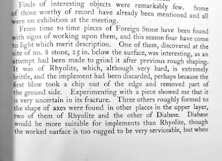


Following its rediscovery in Salisbury Museum it has has be re-examined and the results are: "rhyolitic tuff (which) shows all the key characteristics needed to assign it to Rhyolite Group C from Craig Rhos-y-Felin in north Pembrokeshire, over 170 kilometres south of North Wales – the ‘glacial striae’ are in fact seen to be linear expressions of the internal fabric of the rock, or slickensiding, along one joint plane."

When the news of its rediscovery was first made public along with the thoughts that it might be a rhyolite with striae on it I was reminded of a very similar boulder pictured at Craig Rhos-y-Felin in John, Brian & Elis-Gruffydd, Dyfed & Downes, John. (2015). OBSERVATIONS ON THE SUPPOSED “NEOLITHIC BLUESTONE QUARRY” AT CRAIG RHOSYFELIN, PEMBROKESHIRE. Archaeology in Wales. 54. 139-148.  

Photo by Brian John

With a touch of photoshop the picture of the Newall Boulder can be superimposed on that photo and it can be seen that the shape of it is exactly as it might have been at the quarry where it originated. No glacial transport needed to explain its shape.

It was brought from Pembrokeshire along with the other bluestones. Nothing about it supports a glacial transport theory.