Monday 27 June 2022

The Stonehenge Anti-bird netting story.

On Nov. 28th, 1768 the pioneering ecologist  Gilbert White wrote:

"Another .. spot is made use of by daws (corvi monedulæ) as a place to breed in, and that is Stonehenge. These birds deposit their nests in the interstices between the upright and the impost stones of that amazing work of antiquity: which circumstance alone speaks the prodigious height of the upright stones, that they should be tall enough to secure those nests from the annoyance of shepherd-boys, who are always idling round that place."


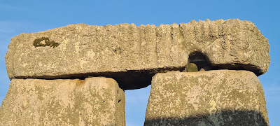
But no longer - in 2021 anti-bird netting was inserted into their ancestral home above Stone 52 to prevent nesting. As a Daw of Stonehenge, so to speak, I have always taken an interest in them.

Just noting this on Twitter unexpectedly provoked an outpouring of outrage so I thought a little background might help.


Following a close up physical investigation (pictured) on 27th March 2019 it was decided that restoration work on the lintels was desirable.

 Photo from @EH_Stonehenge

Before any repairing, adding to or altering a scheduled monument can be undertaken a Scheduled Monument Consent (SMC) must be obtained from the Secretary of State for Digital, Culture, Media and Sport through Historic England . It is a criminal offence to carry out or to permit others to carry out unauthorised works to a scheduled monument, i.e. works undertaken without Scheduled Monument Consent.

The SMC is a detailed document that sets out the need for and the proposed work - it is available here 
It is noticeable that it was the welcome replacement of concrete mortar with more suitable lime mortar. And that the lichens were to be protected during the work. No other work was authorised.

There is no mention of birds or bats or of the adding of anti-bird netting to the scheduled monument. 

As the work took place in September the bird nests would not be being used as nests and so can be legally removed.

But it is of course an offence under the Wildlife and Countryside Act 1981 to intentionally or recklessly:
  • disturb bats while they occupy a structure or place used for shelter or protection,
  • obstruct access to a place of shelter or protection.
  • damage or destroy their breeding sites and resting places (even when bats are not present)
All bat species are designated and protected as European protected species (EPS). The National Biodiversity Network Atlas shows that bats are present in the area including Section 41 species which have extra protection. The narrow dark spaces under the lintels would seem to be likely bat roosts so a bat survey will have had to be done and a plan formulated to ensure any bats aren't harmed.

The work of replacing the mortar in September 2021 was explained by English Heritage in a blog post 

English Heritage have kindly provided an explanation of the netting:

"Jackdaws have still been seen nesting happily at Stonehenge this year. We welcome jackdaws to Stonehenge but we also have to consider the conservation of the monument, particularly in certain locations. We have conducted a trial with Historic England to help protect rare lichens, and the ancient stone, from bird muck by placing a fine mesh screen underneath a small number of the monument’s lintels. This was put in prior to nesting season and is being closely monitored."

The results of the trial will be interesting.

Further information from English Heritage came in a statement to the BBC

"A spokesperson from English Heritage, who run the Unesco World Heritage Site, said they introduced the mesh screens beneath some monument lintels last autumn prior to the nesting season.
They said the trial, conducted in consultation with Historic England, is being "closely monitored over a year's cycle".
They added the increase in excrement as the number of jackdaws increased over lockdown was "damaging the rare lichens on the surface of the stone".
"And would eventually affect the surfaces of the ancient stones themselves," they added.
"We welcome jackdaws to Stonehenge but we also have to bear in mind the conservation of the monument, particularly in certain locations.""
UPDATE - I have requested clarification on the trial that is being undertaken - https://www.whatdotheyknow.com/request/anti_bird_netting_at_stonehenge

And someone else has asked about the Bat Survey referenced above.

Information as it is received will posted here.


Thursday 23 June 2022

When a Glacial Erratic isn't a Glacial Erratic

It's very boring having to repeatedly point out that a Glacial Erratic only is evidence of glacial transport to the point where it was naturally deposited. If it has been moved by humans, and there are no records where from, then it adds nothing to the argument. If you don't know where the glacier left it, it don't mean a thing. For erratics the approximate provenancing -- to within a few sq km -- is good enough, exactness would be better but for mapping glacial extent experts agree it is an unrealistic demand, but when there is no evidence as which county or even country it was originally found in then forget about it. 

It is much more interesting to learn about the Keientrekkers (boulder tractors) of Amersfoort, NL

Amersfoort, de Amersfoortse Kei foto6 2012-12-08 10.47

Michielverbeek, CC BY-SA 3.0, via Wikimedia Commons


De Kei Van Amersfoort 1661

Schilderij van de Keitrekking, het feestelijk verslepen van de Amersfoortse Kei binnen de stadsmuren in 1661. Anoniem schilderij.  https://www.utrechtaltijd.nl/verhalen/de-kei-een-uit-de-hand-gelopen-grap/


The history of the Amersfoort Kei from http://www.amersfoortfestivalstad.nl/keistadfeesten 

In 1544 a 'grooten keeselsteen' was mentioned at the Waelberch on the road from Amersfoort to Utrecht. According to the folk tale, Jonkheer Everard Meyster made a bet with a number of friends that he would drive the people of Amersfoort so mad that they would pull the boulder from the Waelberch (near the Stompert near Soesterberg) to the city. 

On June 7, 1661, 400 inhabitants of Amersfoort pulled the boulder on a sled to the Varkensmarkt. When the Amersfoorters realized that they had been stupid enough to put in effort for something that was completely pointless, they buried the boulder in 1672 on the Varkensmarkt. 
Later generations were not ashamed of the incident. In 1903 the boulder was excavated there again and placed on the Utrechtsestraat. In 1932 the boulder was moved to Plantsoen-Zuid near the Arnhemsestraat. During the German occupation, the stone was temporarily buried on the Hof for fear of damage. 
In 1954 the Amersfoortse Kei got a new and for the time being the last pedestal on the Stadsring.. 

In 1961, the Amersfoort middle class wanted to polish the city's image by setting up a boulder park. Since then, the city has been receiving a boulder as a gift from home or abroad for years... 

Tuesday 21 June 2022

Stonehenge Summer Solstice Sunset Alignment - 2022 Update Ten Years on.


In June 2012 I noticed that the tallest stone is twisted compared to the horseshoe arrangements of the Trilithons  http://www.sarsen.org/2012/06/twisted-stone-56.html . I worked on this idea in various blog posts and eventually published a paper The Twisted Trilithon of Stonehenge 

As noted at https://www.sarsen.org/2014/06/stonehenge-summer-solstice-sun-set.html I expected the sun to set in line with the tallest stone at Stonehenge because of the reasons I set out in my paper 

It didn't let me down, and it wasn't cloudy so I was happy.


Parchmarks 2022 Update

In July 2013 parchmarks at Stonehenge were noticed and recorded. Parchmarks are where the grass is suffering from drought stress due to a difference in the soil compared to the rest of the area. In this context sharply defined ones can be taken as an indication of an archaeologically interesting hole that has refilled with slightly looser chalk which drains better than the undisturbed.

The main observations were of four large marks which indicated where the outer stone circle could have been completed with missing stones. There were also fainter, smaller marks which seemed to indicate a ring of holes between the Z and Y holes.

The 2013 observations were the basis of a paper https://www.researchgate.net/publication/286891547_Parchmarks_at_Stonehenge_July_2013  and a commentary https://mikepitts.wordpress.com/2014/09/01/at-last-a-stonehenge-story-that-is-exactly-what-it-says/ which is a very good summary and has this plan showing the rings of marks outside the stone circle.

The four stonehole marks of the outer sarsen circle have retrospectively been spotted in photos from many different years. (Whether all the stoneholes ever held stones is not known, but that the circle was at least designed to be a complete circle is fairly certain and this was the first proof of it. - see https://www.theguardian.com/culture/2014/sep/01/stonehenge-dry-spell-grass-perfect-circle )

For a less academic take there were headlines such as Happy Accident With Garden Hose Leads To 'Really Significant' Stonehenge Discovery

The outer marks are harder to spot and more elusive. They also are within areas that have been disturbed and even had support struts inserted in them. So I was pleased to be able to spot them again last night before the Solstice revellers took over the site. They are not just a one year phenomenon. I am convinced that there is another ring equidistant between the two known rings.

Click pictures to embiggen them.


They are very faint and for those without the eye of faith a labelled version:


And back in 2013 when they were clearer


For comparison here are the parchmarks in July 2013


Sunday 19 June 2022

The Newall Boulder is RSN18 - ENQ2305 and OU2

 Elsewhere there seems to be confusion about the samples from "the Newall boulder" and their labels.

" In 1989 the OU team (which included Rob Ixer) examined as many bluestone fragments as they could find, including one that they referred to as RSN18 - ENQ2305. They admitted that they did not know where it had come from, and there was no mention in their text of Newall’s boulder. They renamed it OU2"

Here is a picture of the boulder with a clue for the detective to help in working out the mystery. 


Wednesday 8 June 2022

Natural, Manuport or Artefact?

The boulder discussed below  is an excellent case where the terminology of found stones is important.

A "natural" object is one that is found where nature has placed it and in its natural state.

A manuport is a natural object, especially a stone, that has been carried and deposited somewhere by humans but has not been artificially shaped.

An artefact is usually a simple object showing human workmanship or modification as distinguished from a natural object. It can still be in its natural place, for instance a rock carving.

When discussing glacial transport unless the natural place is known very little can be inferred from an object. Once it has been humanly moved it could come from anywhere. 


The stone under discussion has marks on it and from the limited photos I have it is hard to tell what they are.

Some seem to follow the curve of the stone and appear to be natural foliations. Others appear to be more like incised lines. They might be scratches from glacial transport, or just striae of the rock structure.

If they are glacial then the rock is more likely to be a natural and brought to Salisbury Plain by ice; if they are just the surface of the rock then it is more likely it is a manuport brought from Wales by humans.

But if they are tooling marks where the stone has been dressed, and maybe it was knocked off a megalith, a little sibling to the "Boles Barrow" stone, then it is an artefact.

So skilled examination, rather than speculation from an imperfect photo, is needed to decide what this stone is. Only then can it inform us as to how it ended up under the ground at Stonehenge.
 

Saturday 4 June 2022

An Erratic Source

In: KELLAWAY, G.A.. (Ed.), Hot Springs of Bath. Bath City Council, Bath a small rock is pictured:

This small lump of "bluestone" found at "Stonehenge" in 1924, known as RSN18, was considered by Kellaway as being an important indicator of glacial transport of erratics to the area. The lack of a recorded find spot has been problematic.

Transport of the Stonehenge Bluestones: Testing the Glacial
Hypothesis by JD SCOURSE · 1997 http://publications.thebritishacademy.ac.uk/pubs/proc/files/92p271.pdf highlights this: 


In Hawley's 6th Report Jan 1926 Vol V1 No.1 The Antiquaries Journal which is of his 1924 excavations he describes finding a foreign stone and also a photo of the excavation.

I think the stone pictured in the middle of the very left hand side of the excavations around stone 8, judging by the scale, is about the right depth and size to be the foreign stone he mentions. This provides the original context for the stone.  (Click to embiggen)


Kellaway's description seems to match it very well:


Now we need expert analysis as to whether the striae are glacial marks or simply Rhyolite layers as originally suggested.