Friday, 23 December 2022
Mesolithic Machans
Wednesday, 21 December 2022
How many original entrances did Durrington Walls have?
It seems surprising that the number of entrances that Durrington Walls originally had is uncertain.
1, 2, 4 and even 3 have been suggested.
Saturday, 3 December 2022
The Stonehenge Sarsens didn't float down the Avon
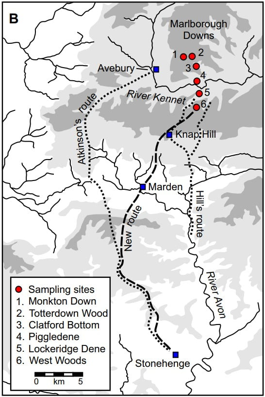
The route that the great sarsens were brought from the Marlborough Downs to Stonehenge is still debated. This blog was started to investigate it and it is still of interest.
I am using 40 tonnes as the maximum weight of an untrimmed sarsen that was moved. The raft or sledge it was moved on then adds to this weight.
The idea that they were brought down the River Avon from Upavon to Amesbury is still popular despite the impossibility of it.
The River Avon we see now isn't the same as it was in Neolithic times, the main difference is that it has historically been dredged, over-widened and impounded in many places due to past river management.
It would have been a multichannel meandering stream in a marshy valley bottom with trees and bushes growing over and in it.
1) They weren't slid on the frozen river.
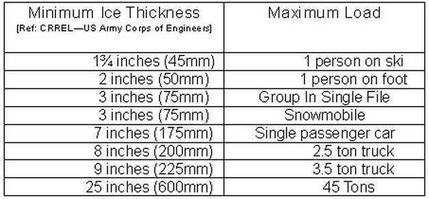
The River Avon is largely fed from ground water along its route, water that is referred to as warm during the winter as it stays at near constant temperature all year round. The river doesn't freeze solid and according to Gold's Formula the ice would need to be over 500mm thick
The River at Amesbury has a normal maximum depth of 700mm and is usually half of that, and at Upavon it is a lot less.
2) They weren't loaded onto rafts and floated down.
To float 40 tonnes of stone 40 cubic metres of water must be displaced. If we had a weightless box to load the stone on it would need to be 4 metres wide, 20 metres long and 500mm deep, the depth of the river being a limiting factor here.
A wooden raft made of logs would need to be much larger. Wood has a specific gravity of 500 - 800 kg per m3 . The photo shows how only half of a log raft is out of the water. At the lightest end the raft would need to weigh another forty tonnes to displace enough water, at a more realistic weight for hardwoods of 750kg/m3 it nearly 100 tonnes. A forty five meter by five meter wide raft at 500 mm deep. The river is not big enough.
Only by using hollowed logs or canoes could the weight and size of the raft be reduced but would they be strong enough for the massive stones?
Dragging heavy stones through an overgrown bog didn't happen, they went overland away from the river.
Sunday, 6 November 2022
Reconstructing extraction techniques at Stonehenge’s bluestone megalith quarries in the Preseli hills of west Wales
A very detailed look at the Bluestone quarries and the associated stone tools discovered there.
Abstract: Excavations at two of the sources of Stonehenge’s bluestones in Mynydd Preseli, west Wales, have led to the discovery of stone tools associated with megalith quarrying in the final centuries of the fourth millennium BC, shortly before the suspected date of the bluestones’ erection at Stonehenge, 240 km away. Among the most plentiful of these tools are stone wedges, three of which were found in situ at the rhyolite bluestone quarry of Craig Rhos-y-felin. Two of these were positioned in the joints of a rhyolite pillar adjacent to a recess left by a removed pillar. Geochemical analysis reveals that these and the third wedge are of compositions different to the rock on either side of the cracks into which they had been driven, confirming their identification as quarrying tools. This research sheds new light on the methods used to extract the stones for Stonehenge.
Reconstructing extraction techniques at Stonehenge’s bluestone megalith quarries in the Preseli hills of west Wales,
Mike Parker Pearson, Richard Bevins, Nick Pearce, Rob Ixer, Josh Pollard, Colin Richards, Kate Welham
Journal of Archaeological Science: Reports,
Volume 46,
2022,
103697,
ISSN 2352-409X,
https://doi.org/10.1016/j.jasrep.2022.103697
(https://www.sciencedirect.com/science/article/pii/S2352409X22003601)
Keywords: Megalith quarries; Dolerite; Rhyolite; Stonehenge; Mynydd Preseli; Neolithic
Friday, 4 November 2022
Mythical rings? Waun Mawn and Stonehenge by Timothy Darvill and the response!
Mythical rings? Waun Mawn and Stonehenge Stage 1 by Timothy Darvill
"In a recent
Antiquity article, Parker Pearson
and colleagues (2021) presented
results from excavations at Waun
Mawn in south-west Wales, interpreting the site
as a dismantled stone circle and source
for some of the Bluestone
pillars used in the Aubrey Holes at Stonehenge. Here, the author examines the evidence, showing that alternative
interpretations are possible. Waun Mawn is argued to represent a series of smaller
stone settings, typical of ceremonial sites in
south- west Wales. Meanwhile
the Aubrey Holes are shown to reflect a well-established regional
sequence in which post circles are followed by pit circles. A Welsh
‘source-circle’ for
Stonehenge cannot be excluded but, the author
argues, the claim is unsupported by the current evidence."
Darvill plan showing the recorded stones
and stone-sockets at Waun Mawn,
Pembrokeshire (figure by G. Belmont
after Grimes 1964: fig. 36 and Parker Pearson
et
al. 2021: fig. 4a).
Tuesday, 11 October 2022
The 52 Hillforts of Wiltshire
|
Name |
Longitude |
Latitude |
|
|
1 |
Castle Hill, Blunsdon St Andrew |
-1.77441 |
51.61914 |
|
2 |
Bury Hill Camp, Purton |
-1.9183 |
51.60967 |
|
3 |
Nuns Walk, Malmesbury. |
-2.09482 |
51.58369 |
|
4 |
Ringsbury Camp |
-1.89333 |
51.57961 |
|
5 |
Liddington Castle |
-1.70066 |
51.51583 |
|
6 |
Bincknoll Castle |
-1.84618 |
51.51221 |
|
7 |
Barbury Castle |
-1.78635 |
51.48527 |
|
8 |
Membury Camp |
-1.56636 |
51.47567 |
|
9 |
Bury Wood Camp |
-2.2632 |
51.46427 |
|
10 |
Nash Hill |
-2.09702 |
51.42346 |
|
11 |
Oldbury Castle |
-1.93037 |
51.42246 |
|
12 |
Chisbury Camp |
-1.60051 |
51.39205 |
|
13 |
Oliver's Castle |
-1.99994 |
51.38113 |
|
14 |
Rybury Camp |
-1.88173 |
51.37463 |
|
15 |
Martinsell Hill Camp |
-1.7514 |
51.37447 |
|
16 |
Giant's Grave |
-1.76244 |
51.36796 |
|
17 |
Budbury |
-2.25754 |
51.34854 |
|
18 |
Godsbury |
-1.68904 |
51.31853 |
|
19 |
Fosbury Camp |
-1.54311 |
51.30692 |
|
20 |
Broadbury Banks |
-1.86838 |
51.29888 |
|
21 |
Castle Combe |
-2.14601 |
51.29561 |
|
22 |
Sunton |
-1.65939 |
51.28765 |
|
23 |
Chisenbury Camp |
-1.78358 |
51.28374 |
|
24 |
Casterley Camp |
-1.83531 |
51.28101 |
|
25 |
Bratton Castle |
-2.14302 |
51.26376 |
|
26 |
Sidbury Camp |
-1.6913 |
51.25365 |
|
27 |
Battlesbury Camp |
-2.14668 |
51.20994 |
|
28 |
Cley Hill Camp |
-2.23204 |
51.20298 |
|
29 |
Scratchbury Camp |
-2.1262 |
51.19727 |
|
30 |
Knook Castle |
-2.05856 |
51.19553 |
|
31 |
Vespasian's Camp |
-1.79108 |
51.17399 |
|
32 |
Codford Circle |
-2.02644 |
51.16419 |
|
33 |
Yarnbury Castle |
-1.95097 |
51.16271 |
|
34 |
Ludgershall Castle |
-1.37222 |
51.15252 |
|
35 |
Ogbury Camp |
-1.79669 |
51.14368 |
|
36 |
Bilbury Rings |
-1.98711 |
51.12541 |
|
37 |
Grovely Castle |
-1.93238 |
51.12132 |
|
38 |
Ebsbury Hill |
-1.91339 |
51.11762 |
|
39 |
Park Hill Camp |
-2.33901 |
51.11122 |
|
40 |
White Sheet Castle |
-2.28097 |
51.11032 |
|
41 |
Figsbury Ring |
-1.73232 |
51.10337 |
|
42 |
Kenwalch's Castle |
-2.36163 |
51.10056 |
|
43 |
Old Sarum |
-1.80464 |
51.09337 |
|
44 |
Wick Ball Camp |
-2.00071 |
51.08687 |
|
45 |
Castle Ditches, Tisbury |
-2.0533 |
51.05463 |
|
46 |
Chiselbury |
-1.97559 |
51.05239 |
|
47 |
Great Woodbury |
-1.79653 |
51.04969 |
|
48 |
Odstock Copse |
-1.79517 |
51.02569 |
|
49 |
Castle Rings, Donhead St Mary |
-2.16153 |
51.02501 |
|
50 |
Clearbury Ring |
-1.78401 |
51.01836 |
|
51 |
Winklebury Camp |
-2.06945 |
50.99478 |
|
52 |
The Earldoms |
-1.64684 |
50.99299 |

This work is licensed under a Creative Commons Attribution-ShareAlike 4.0 International License.
Saturday, 8 October 2022
Strontium Values Reappraisal - The South-West not Scotland?
That pigs, cattle, humans and even a dog came to the Stonehenge area from distant parts in prehistory has been one of the more interesting scientific discoveries of recent times. The links to Orcadian culture has also been speculated on.
Behind the headlines and speculation there is solid research - some links to start from:
Evans, J., Parker Pearson, M., Madgwick, R. et al. Strontium and oxygen isotope evidence for the origin and movement of cattle at Late Neolithic Durrington Walls, UK. Archaeol Anthropol Sci 11, 5181–5197 (2019). https://doi.org/10.1007/s12520-019-00849-wGordon J. Barclay & Kenneth Brophy (2020): ‘A veritable chauvinism of prehistory’: nationalist prehistories and the ‘British’ late Neolithic mythos, Archaeological Journal, DOI: 10.1080/00665983.2020.1769399
The ‘omphalos of Britain’: iconic sites and landscapes, methodological nationalism and conceptual conservatism in the writing of ‘British’ prehistory. A reply to Madgwick and collaborators 2021 Gordon J. Barclay and Kenneth Brophy DOI: 10.6084/m9.figshare.17296994