
Th detailed report on the causewayed enclose is at http://archaeologydataservice.ac.uk/archiveDS/archiveDownload?t=arch-1416-1/dissemination/pdf/9781848021877_ALL.pdf
Britain from Above has some 1947 photos of the area as well:


| Stone No. | Volume (m³) | Estimated above ground weight (tonnes) | Additional visible fragments |
| 1 | 5.45 | 13.08 | |
| 2 | 8.03 | 19.27 | |
| 3 | 5.55 | 13.32 | |
| 4 | 6.66 | 15.98 | |
| 5 | 5.64 | 13.53 | |
| 6 | 5.54 | 13.29 | |
| 7 | 5.97 | 14.32 | |
| 8* | 0.65 | 1.56 | |
| 9a/b | 0.25 | 0.29 | 1 |
| 10 | 7.07 | 16.96 | |
| 11† | 2.03 | 4.87 | |
| 12‡ | 6.32 | 15.16 | |
| 14‡ | 2.91 | 6.98 | |
| 15* | 1.31 | 3.14 | |
| 16 | 9.8 | 23.52 | |
| 19* | 1.65 | 3.96 | |
| 21 | 4.61 | 11.06 | |
| 22 | 5.47 | 13.128 | |
| 23 | 4.92 | 11.8 | |
| 25* | 2.95 | 7.08 | |
| 26* | 0.4 | 0.96 | |
| 27 | 5.21 | 12.48 | |
| 28 | 9.08 | 21.792 | |
| 29 | 6.95 | 16.68 | |
| 30 | 7.75 | 18.6 | |
| 51 | 9.86 | 23.66 | |
| 52 | 11.54 | 27.69 | |
| 53 | 7.56 | 18.14 | |
| 54 | 12.22 | 29.32 | |
| 55a/b | 6.6 | 15.84 | 1 |
| 56 | 9.61 | 23.06 | |
| 57 | 11.64 | 27.93 | |
| 58 | 10.02 | 24.04 | |
| 59a/b/c* | 9.1 | 21.84 | 2 |
| 60 | 9.01 | 21.62 | |
| 91 | 1.16 | 2.78 | |
| 93 | 0.56 | 1.34 | |
| 95‡ | 1.75 | 4.2 | |
| 96 | 12.47 | 29.92 | |
| 101 | 1.88 | 4.51 | |
| 102 | 2.7 | 6.48 | |
| 105 | 1.59 | 3.81 | |
| 107 | 2.1 | 5.04 | |
| 120* | 0.49 | 1.17 | |
| 122 | 2.7 | 6.48 | |
| 127* | 0.6 | 1.44 | |
| 130 | 2.6 | 6.24 | |
| 152 | 4.89 | 11.73 | |
| 154 | 7.29 | 17.49 | |
| 156 | 3.7 | 8.88 | |
| 158 | 6.9 | 16.56 | |
| 160* | 2.09 | 5.01 | 2 |
| 31 | 0.68 | 2.04 | |
| 32‡ | 0.38 | 1.14 | |
| 33 | 0.17 | 0.51 | |
| 34 | 0.11 | 0.33 | |
| 35a‡ | 0.0007 | 0.002 | |
| 35b‡ | 0.003 | 0.01 | |
| 36‡ | 0.09 | 0.27 | |
| 37 | 0.27 | 0.81 | |
| 38 | |||
| 39‡ | 0.16 | 0.48 | |
| 40 | |||
| 41‡ | 0.24 | 0.72 | |
| 42‡ | 0.1 | 0.3 | |
| 43 | |||
| 44 | |||
| 45‡ | 0.14 | 0.42 | |
| 46† | 0.14 | 0.34 | |
| 47 | 0.42 | 1.26 | |
| 48‡† | 0.066 | 0.16 | |
| 49 | 0.37 | 1.11 | |
| 61 | 0.32 | 0.96 | 1 |
| 62 | 0.41 | 1.23 | |
| 63 | 0.4 | 1.2 | |
| 64 | |||
| 65 66 | |||
| 67‡ | 0.53 | 1.59 | |
| 68 | 0.71 | 2.13 | |
| 69 | 0.72 | 2.16 | |
| 70 | 0.41 | 1.23 | |
| 72* | 0.51 | 1.53 | |
| 80 Altar Stone | 1 | ||
| 150 | |||
| Totals: | |||
| 85 | 680.962 | 8 | |
| Total Visible Stones 93 |
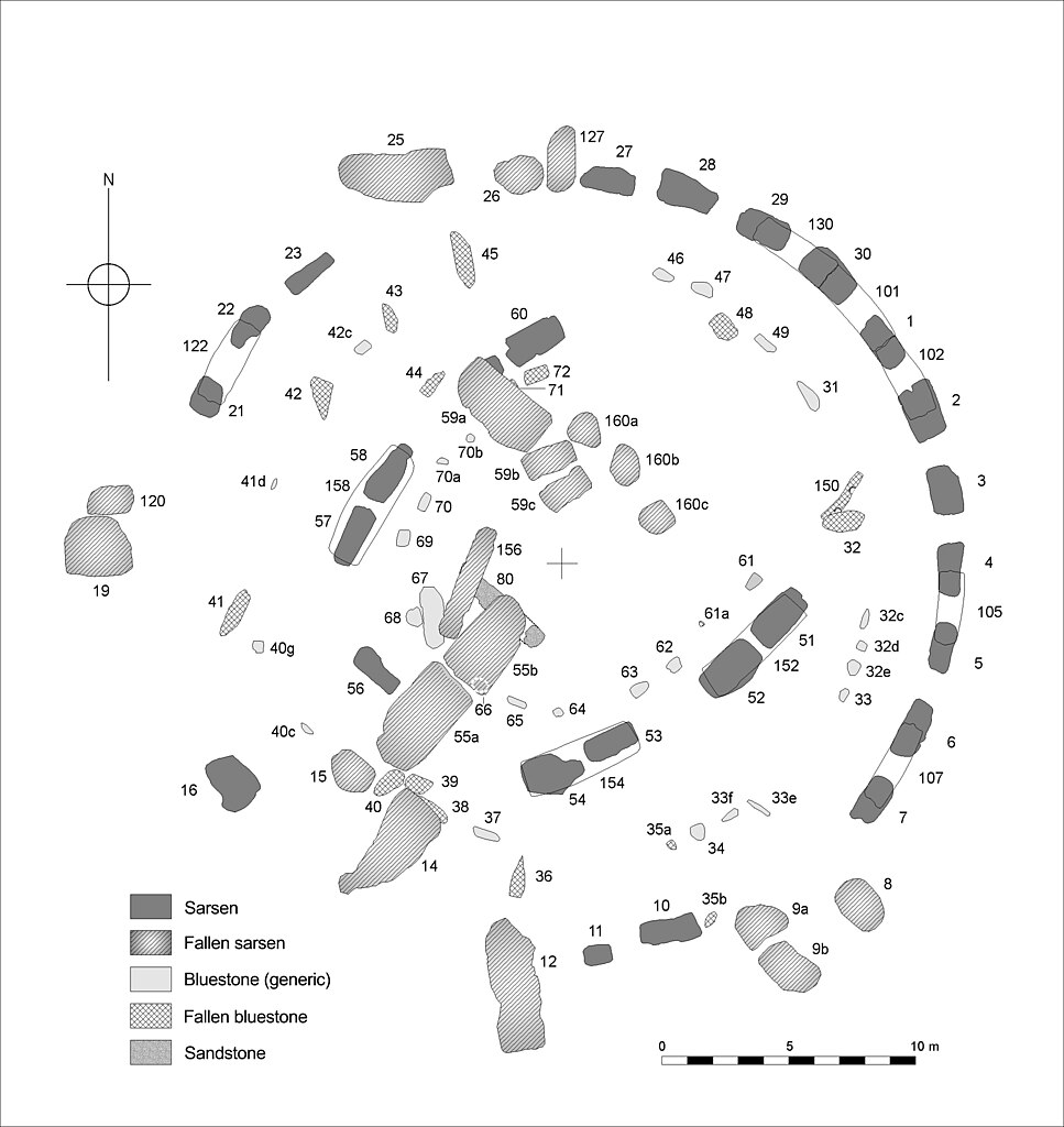 |
 |
| Click to enlarge |

‘The History of Ancient Wiltshire’ First Edition Published 1812 ( Volume 1)
‘We speak from facts not theory’
Working alongside William Cunnington (who unfortunately died just before this book was published). Sir Richard Colt Hoare excavated 379 barrows on Salisbury Plain as well as identifying many other sites in the area. A dedication is included to William Cunnington at the beginning of the book, which is digitsed below .
Sir Richard Colt Hoare was born on 9 December 1758 and died on 19 May 1838. He purchased Glastonbury Tor in 1786 and funded the restoration of the church tower on top of it. His mausoleum is in St Peters church Stourton Wiltshire.
Thank you to Sir Antrobus, Fred Westmoreland , Amesbury History Centre, Colin Wheeler and Elms Creative Limited who have enabled Silent Earth to digitise and publish Sir Richard Colt Hoares seminal work here.
https://issuu.com/silentearth/docs/silent_earth_-_ebook__coare_hare__2
