This is a fuller copy of the letter I sent British Archaeology which was published in Issue 132 in an edited, and more readable, form. It was written before I noticed the parch marks so it was very prescient.
For they look, but they don't
really see – Matthew 13:13
Frank Stevens’ guidebook to Stonehenge was first published
in 1916 and continued in print until 1938. It is still admired especially for
the woodcut illustrations by Heywood Sumner. The first one is this.
But there is a problem with this illustration which Stonehenge geeks may notice immediately but seems not to have been noticed when the book was in print.
There is a second mistake which is with the caption, the view is towards the north east, not the south east; a mistake I have only just noticed despite studying this picture many times over the last year.
As a clue here is a contemporary postcard from Frith’s showing the same scene, which also has a similar captioning mistake saying it is “from the N.W” when it is from the South West:
Here is an earlier version of the picture:
The problem, if you didn’t notice it is that the tall stone,
stone 56, was straightened on the 19th September 1901.
It seems that the postcard printers altered the picture
rather than have a new photo taken.
Which was a shame as on the evening of the 31st December
1900, the trilithon on the left, Stones 21,22 and 122, was blown down in the
course of a severe storm. So you can have stone 56 upright with 22 fallen or 56
leaning with 22 standing or for eighteen months 56 leaning and 22 fallen, but
at no time in the early twentieth century were 56 and 22 both upright.
So the illustration in the official guidebook was taken from
a faked photograph and not from reality.
The history of Stonehenge is full of examples of people
looking at it but not really seeing it.
From the public path looking across the width of the
monument the dagger carvings on Stone 53 can be seen clearly on any sunny
afternoon. But it seems no one noticed them until Richard Atkinson did in July
1953. They show up in early photographs; they are in view but not seen. Once
they were seen many other were spotted. When we know what to look for we can
easily see it, it is much harder to see something we don’t expect to see.
In the 1960s C A “Peter” Newham and Gerald Hawkins, and
others, looked for astronomical alignments at Stonehenge. This illustration is from Hawkins’ book.
Peter Newham produced a similar one, below, which
concentrates on the Station Stones and the indeterminate F, G and H holes (some
authorities think they may be natural rather than man made features).
Peter hypothesised a hole G2 to make an alignment to Station
Stone 92 to match the alignment from Station Stone 94 to Hole G which is to the
Winter Solstice Sunrise and Summer Solstice Sunset. Gerald Hawkins thought this
line was between Station Stone 93 and Hole H.
Whilst they were busy looking at the small Station Stones
and on plans where missing stones and holes were they failed to see a much
larger object already on this alignment towering over them.
As to whether the alignment is a real artefact or not is
another argument, what is indisputable is that many people were looking for it.
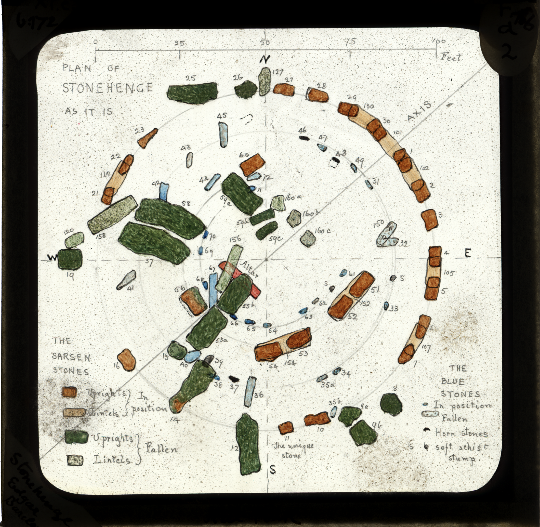
The Great Trilithon at the centre of the inner sarsen horseshoe
consisted of Stones 55, 56 and the lintel 156. 156 lies on the ground beside
the broken 55 but Stone 56, as mentioned above, stands upright. It has, as did
55, highly worked flat sides. But these sides are not symmetrical to the
horseshoe or the acknowledged Summer Solstice Sunrise – Winter Solstice Sunset
alignment through the monument. The
stone is skewed about 10 degrees from this line, which puts it on the alignment
that Hawkins, Newham and other were looking for.
It might be argued that Gowland, who straightened the stone
did not get it back into its original position but close examination of his
records and acknowledgement of his skill and experience makes this unlikely. He
stated that the original position of Stone 55 and thus the whole trilithon was
in line with 56.
I believe that the skewing is significant, others may not, but either way
millions of people have looked at it and investigators have studied it
but they all failed to see it and what it might mean.
There is still a lot to be properly seen at Stonehenge.




 Stonehenge Aerial Photo from the South West - 1920s - Click to enlarge