Friday, 16 January 2026

Low Hanging Stones

 I'm reading Stonehenge Deciphered: A Critical Reading of Geometry, Landscape, and Intention by Alun G. Rees (2025) and I noticed his explanation of a possible way to raft the Bluestones from Wales. It is fairly standard and one I have often used, though I'm a dryland route man by preference. I'm surprised a few commentators think it is a new theory though.

I used an illustration by Billy Colfer from a Newgrange book to show it back in 2012, I seem to remember that millstones quarried from cliffs in Ireland were moved in a similar manner in more modern historical times.


The diagrams are from the excellent book "Newgrange".

Tuesday, 13 January 2026

Pleistocene Glacial and Periglacial Features in Somerset: Limits of Ice Advance and Local Dynamics in the Levels and Mendips

Map of Somerset Levels

The Pleistocene history of Somerset mirrors that of north Devon in many respects, characterised by peripheral interactions with the Irish Sea Ice Sheet rather than extensive inland glaciation. The Somerset Levels—a low-lying coastal plain prone to flooding—and the adjacent Mendip Hills exhibit a record of ice-marginal deposits, periglacial processes, and interglacial marine incursions, but without evidence of widespread ice override or floating sea ice penetrating deep into the interior. This reflects the region's position at the southern fringe of the British-Irish Ice Sheet, where glacial advances during stages such as the Anglian (Marine Isotope Stage 12, around 478,000–424,000 years ago) or Wolstonian were constrained by topography and climate, leading to localised sedimentation from meltwater and periglacial activity rather than broad ice-sheet coverage.

In the Somerset Levels, glacial deposits indicate limited ingress by the Irish Sea lobe, primarily in the northern areas around Clevedon and Kenn. Here, the Kenn Formation includes tills (diamictons with striated boulders), glaciofluvial gravels, and outwash sands, exposed in col-gullies like Court Hill and Nightingale Valley. These sequences, featuring erratic clasts such as Chalk flints, Greensand chert, and Cretaceous microfossils derived from the west, suggest an ice-marginal environment with proglacial outwash and possible flow tills, but no subglacial deformation indicative of extensive advance. (Note: While major Cretaceous chalk outcrops are concentrated in eastern and southeastern England, such as the North and South Downs, the chalk flints and related erratics in these Somerset deposits were sourced from exposures in the Irish Sea Basin, including the Antrim Chalk in Northern Ireland and possibly seabed sediments or outcrops in northwest Wales. These were entrained by the Irish Sea Ice Sheet and transported southwards and eastwards into the Bristol Channel, explaining their "western" provenance despite the material's geological association with eastern formations.) The deposits are interpreted as dating to a pre-Anglian or Wolstonian event, with the ice front impinging from the Bristol Channel but not progressing far southward; for instance, southern sites like Greylake show only rare glacigenic elements in basal diamictons, and erratic-free gravels dominate further inland. Interglacial marine and estuarine units, such as the Burtle Formation (shelly sands and gravels up to 5–10 metres OD, correlated with Stages 9, 7, and 5e) and Yew Tree Formation (estuarine silts with marine molluscs like Macoma balthica), overlie or interdigitate with these, highlighting episodic sea-level rises during warmer periods without glacial involvement. Periglacial features in the Levels include aeolian coversands, cryoturbated breccias, and colluvial silts, as seen at Holly Lane near Clevedon, where niveo-aeolian loams and frost-shattered limestones reflect cold, dry Devensian conditions (Stages 4–2) with tundra-like vegetation indicated by molluscs such as Pupilla muscorum.

The Mendip Hills, rising to around 300 metres OD, experienced predominantly periglacial activity, with no direct evidence of ice-sheet coverage or independent ice caps akin to those on Dartmoor. Slope deposits and alluvial fans dominate, such as at Bourne and Wookey Station, where fan gravels with cryoturbation, involutions, and cold-stage molluscs (e.g., Pupilla muscorum, Carychium arenaria) indicate mass movement and braided stream deposition under periglacial regimes. These are interspersed with palaeosols reflecting brief interstadials, and aeolian sands derived from distant sources (e.g., Tertiary deposits in Devon) point to wind-blown transport during arid cold phases. At Brean Down on the Mendip fringe, a sequence of rockfall breccias, aeolian silts, and palaeosols spans the Devensian, with fossil mammals (reindeer, arctic fox) and molluscs suggesting steppe-tundra landscapes and minor climatic ameliorations, possibly correlating with Stage 3 interstadials. Glacial influence is marginal at best; enigmatic glaciofluvial gravels at Bleadon Hill contain local Carboniferous Limestone clasts, potentially linked to proglacial lake shores or outwash from Irish Sea ice nearby, but without far-travelled erratics confirming override. Karstic fissures in the Mendips, such as at Bathampton Down, contain recycled erratics (flint, chert) in infill gravels, suggesting periglacial reworking rather than direct glacial emplacement.

Critically, these deposits do not indicate high sea levels facilitating floating ice or marine incursions deep into Somerset during glacial maxima. As in Devon, Pleistocene cold stages coincided with global sea-level drops exceeding 100 metres, exposing the Bristol Channel and facilitating terrestrial periglacial processes rather than glaciomarine environments. Deposits lack marine microfossils in inland contexts, and erratics at higher elevations (e.g., up to 20–30 metres OD in terraces) are attributed to periglacial solifluction or fluvial reworking from earlier events, not to ice-rafting during elevated sea stands. The notion of inflowing sea ice is unsupported, as coastal erratics (e.g., at Weston-in-Gordano) are confined to low elevations and tied to interstadial highstands, not peak glaciation.

In essence, the Somerset Levels and Mendip Hills exemplify a constrained Pleistocene glaciation similar to north Devon's: marginal impingement by the Irish Sea lobe in the lowlands, creating limited outwash and tills without further inland flow, complemented by pervasive periglacial weathering on the hills. This peripheral dynamic, driven by local topography and without coalescence with larger ice sheets, accounts for the observed features through meltwater, solifluction, and aeolian processes, aligning with reconstructions of the British-Irish Ice Sheet's southern limits. Persistent suggestions that the Irish Sea Ice Sheet overrode the Mendips or extended further east across the chalk escarpment to deliver erratics to Salisbury Plain are refuted by multiple lines of evidence. Firstly, there is a complete absence of glacial drift, tills, or subglacial features on the Mendip plateau or its interior; instead, the hills show only periglacial slope deposits, cryoturbation, and aeolian sands, with any recycled erratics in karst fissures attributable to solifluction rather than direct ice emplacement. The ice lobe's contact was limited to the eastern margin of the Mendips at the Somerset Levels, with no evidence of overriding the hills, as confirmed by the lack of striations or erratics on higher ground. Secondly, the easternmost glacial limit in Somerset is marked by scattered deposits in the Bridgwater-Glastonbury area, well short of the chalk escarpment in Wiltshire; beyond this, sediments transition to erratic-free fluvial and periglacial materials. On Salisbury Plain itself, there are no glacial deposits, moraines, or far-travelled erratics from Irish Sea sources that would be expected from an overriding ice sheet capable of transporting large lithologies; Stonehenge bluestones are instead explained by human transport. Geochemical provenancing matches the bluestones to specific Welsh quarries without requiring glacial intervention, and the absence of intermediate glacial drifts between Preseli and Salisbury Plain undermines long-distance ice transport theories. Overall, the southern limits of the Irish Sea Ice Sheet are firmly established in the Bristol Channel and coastal Somerset, with no stratigraphic, geomorphological, or sedimentological support for extensions over the Mendips or to Salisbury Plain. Further optically stimulated luminescence (OSL) dating and sediment provenance studies could refine chronologies, but the consensus highlights distinctly localised phenomena in this extra-glacial landscape.

References

Pleistocene Glacial and Periglacial Features in Devon: Limits of Ice Advance and Local Upland Dynamics

 The Hele-Bickington Ridge and Fremington Clays Superficial Deposits

Click to embiggen - Source 

The Pleistocene epoch, spanning roughly 2.6 million to 11,700 years ago, witnessed multiple glaciations across Britain, with the Irish Sea Ice Sheet playing a prominent role in shaping the landscapes of southwest England. In north Devon, particularly around the Taw Estuary, key deposits such as those on the Hele–Bickington ridge and the Fremington Clay provide valuable evidence of ice-marginal processes. These features illustrate how the glacier reached its southern limits without extending significantly further inland or eastward, and they highlight the role of meltwater and damming rather than widespread marine or floating ice incursions into the Devon interior. This interpretation aligns with a consensus in Quaternary geology that emphasises localised glacial impacts in the region, driven by the Irish Sea lobe during stages like the Wolstonian (Marine Isotope Stage 6, around 191,000–130,000 years ago).

The Hele–Bickington ridge, a low-lying east–west trending feature rising to about 55–56 metres above Ordnance Datum (OD) near Barnstaple, is capped by several metres of sand and gravel deposits known as the Hele gravels. These are interpreted as glaciofluvial outwash—sorted sediments laid down by meltwater streams emanating from the glacier's margin—rather than direct glacial till or a moraine formed by ice advance. The ridge itself is a pre-existing topographic element, primarily composed of underlying Carboniferous bedrock, with the gravels representing ice-proximal deposition during the glacier's furthest inland reach up the Taw Estuary. This positions the ridge as an ice-marginal feature, marking the southernmost extent of the Irish Sea glacier in this area, likely during a Middle Pleistocene event. Importantly, there is no evidence of similar deposits or landforms further east or south, suggesting the ice did not flow beyond this point; instead, it impinged on the estuary and retreated, leaving behind meltwater channels and outwash without overrunning inland terrains.

Adjacent to the ridge, the Fremington Clay forms a continuous body of fine-grained sediments extending about 4 kilometres between Fremington and Lake, with thicknesses up to 24 metres. These clays interdigitate with the basal gravels of the ridge, indicating a shared origin tied to the same glacial event. Rather than representing direct till from advancing ice or marine deposits from high sea levels, the clays are commonly viewed as glaciolacustrine in nature—formed in an ice-dammed lake created when the glacier's front blocked drainage in the Taw Valley. Meltwater from the static ice margin ponded eastward, allowing quiet-water sedimentation of laminated silts and clays, with occasional erratics (far-travelled boulders) incorporated from the glacier. While some researchers have proposed alternative fluvial or periglacial origins for parts of the sequence, the presence of exotic clasts from the Irish Sea Basin and the stratigraphic context support a predominantly glacial damming mechanism, without requiring ice override or extensive flow.

In the uplands of Devon, particularly on Dartmoor and Exmoor, higher-altitude landforms and deposits reflect predominantly local periglacial and glacial processes during the Pleistocene, rather than incursions from the Irish Sea Ice Sheet or floating sea ice extending inland. These features, often found above 200–300 metres OD, include tors, blockfields, solifluction lobes, and subtle morainic ridges, which are products of intense freeze-thaw cycles, mass movement under periglacial conditions, and small-scale glaciation confined to the moors themselves. This localised origin contrasts with lower-altitude coastal and estuarine deposits (such as those in the Taw Estuary) that show evidence of interaction with the Irish Sea glacier lobe, but without widespread inland penetration.

Dartmoor, with summits exceeding 600 metres, hosted the southernmost independent Pleistocene ice cap in the British Isles, centred on its northern plateau during colder phases like the Devensian (Last Glacial Maximum, approximately 26,000–11,700 years ago). Evidence includes overdeepened U-shaped valleys, arcuate bouldery ridges, and hummocky valley-floor drift, interpreted as remnants of a plateau icefield with outlet glaciers extending into marginal valleys. These glaciers were nourished by local precipitation and snowblow, producing cold-based ice that minimally eroded the granite bedrock while depositing thin moraines. Similarly, Exmoor supported small ice caps on its plateau surfaces (around 400–500 metres OD), with glacial tills and moraines indicating valley glaciation during the same periods. Numerical modelling supports the feasibility of these ice masses under Pleistocene climatic conditions, with ice thicknesses sufficient for flow but limited in extent.

Periglacial features dominate at higher elevations across Devon, including patterned ground, gelifluction sheets, and tors formed through prolonged frost weathering rather than glacial scour. These are emblematic of "average glacial conditions" where the uplands experienced repeated cold stages without full ice-sheet coverage, leading to solifluction and downslope movement of regolith.

Critically, these deposits do not indicate high sea levels facilitating floating ice or marine incursions deep into Devon during glacial maxima. Pleistocene glaciations in the region coincided with lowered global sea levels due to water locked in ice sheets, often dropping by over 100 metres. Evidence from north Devon, including river terraces graded to these low bases and the absence of widespread marine sediments inland, points to terrestrial or freshwater environments rather than elevated sea-ice penetration. The notion of "inflowing sea ice" – implying floating icebergs or ice-rafted debris from marine incursions deep into Devon – is not supported by the evidence. During glacial maxima, global sea levels were lowered by over 100 metres, exposing the Bristol Channel as a terrestrial corridor and preventing significant marine ice penetration inland. While ice-rafted erratics occur along the coasts (e.g., at Saunton and Croyde), potentially from Irish Sea sources during higher sea-level interstadials, these are confined to low elevations (0–10 metres OD) and do not extend to higher upland features. Inland deposits lack marine microfossils or sedimentary structures indicative of glaciomarine environments, further ruling out widespread sea-ice influence.

In essence, the Hele–Bickington ridge and Fremington Clay exemplify the constrained nature of Pleistocene glaciation in north Devon: a marginal impingement by the Irish Sea lobe that created static, dammed lakes and outwash fans, without evidence of further eastward ice flow or high-level marine ice incursions. This underscores the region's position at the periphery of major British ice sheets, where periglacial and meltwater processes dominated landscape evolution, with Devon's higher-altitude Quaternary landscape shaped by endogenous processes: periglacial weathering across the moors and small, independent ice caps on Dartmoor and Exmoor that did not coalesce with the larger Irish Sea Ice Sheet. This localised glaciation, combined with periglacial activity, accounts for the observed features without invoking external sea-ice inflows, aligning with broader reconstructions of the British-Irish Ice Sheet's peripheral dynamics. Ongoing cosmogenic dating and geomorphological mapping could further clarify timings, but the current consensus emphasises these as distinctly local phenomena.

References

  1. The glaciation of Dartmoor: the southernmost independent Pleistocene ice cap in the British Isles - ScienceDirect - https://www.sciencedirect.com/science/article/abs/pii/S0277379112001667
  2. The glaciation of Dartmoor: The southernmost independent Pleistocene ice cap in the British Isles - ResearchGate - https://www.researchgate.net/publication/258707211_The_glaciation_of_Dartmoor_The_southernmost_independent_Pleistocene_ice_cap_in_the_British_Isles
  3. The myth of "periglacial Dartmoor" - Stonehenge and the Ice Age - https://brian-mountainman.blogspot.com/2012/06/myth-of-periglacial-dartmoor.html
  4. The Glaciation of Dartmoor - https://dartmoorsociety.com/pastevent/the-glaciation-of-dartmoor
  5. Dartmoor's overlooked glacial legacy - Evans - 2012 - Geology Today - Wiley Online Library - https://onlinelibrary.wiley.com/doi/10.1111/j.1365-2451.2012.00855.x
  6. Full article: Periglacial landforms of Dartmoor: an automated mapping approach to characterizing cold climate geomorphology - Taylor & Francis Online - https://www.tandfonline.com/doi/full/10.1080/14702541.2022.2093394
  7. Dartmoor glaciation - https://ougs.org/files/ouc/archive/proceedings/POUGS_3/proceedings-ougs-3-2017-73-86-harrison.pdf
  8. The glaciation of Dartmoor: the southernmost independent Pleistocene ice cap in the British Isles - NASA/ADS - https://ui.adsabs.harvard.edu/abs/2012QSRv...45...31E/abstract
  9. The southernmost Quaternary niche glacier system in Great Britain - White Rose Research Online - https://eprints.whiterose.ac.uk/id/eprint/87757/7/WRRO_87757.pdf
  10. Further glacial tills on Exmoor, southwest England: implications for small ice cap and valley glaciation - ScienceDirect - https://www.sciencedirect.com/science/article/abs/pii/S0016787801800432
  11. The Quaternary Geology of Devon - The Ussher Society - https://ussher.org.uk/wp-content/uploads/benettetal1584130v2.pdf
  12. The myth of "periglacial Dartmoor" - Stonehenge and the Ice Age - https://brian-mountainman.blogspot.com/2012/06/myth-of-periglacial-dartmoor.html
  13. The Quaternary Geology of Devon - Sign in - The University of Manchester - https://pure.manchester.ac.uk/ws/portalfiles/portal/347990201/24338_USSHER_SOCIETY_GEOLOGY_FINAL.pdf
  14. Chapter 7 (The Quaternary history of north Devon and west Somerset) - JNCC Open Data - https://data.jncc.gov.uk/data/965f9190-c00b-4a6b-aa9f-8e3855492404/gcr-v14-quaternary-of-south-west-england-c7.pdf
  15. Caution in Attributing the Fremington Clay Series to Irish Sea Glaciation: A Case for Predominantly Fluvial and Periglacial Origins in North Devon - Academia.edu - https://www.academia.edu/144683132/Caution_in_Attributing_the_Fremington_Clay_Series_to_Irish_Sea_Glaciation_A_Case_for_Predominantly_Fluvial_and_Periglacial_Origins_in_North_Devon
  16. The timing and magnitude of the British–Irish Ice Sheet between Marine Isotope Stages 5d and 2 - Archimer - https://archimer.ifremer.fr/doc/00882/99393/109415.pdf
  17. A Re-Appraisal of the Erratic Suite of the Saunton and Croyde Areas, North Devon - https://devonassoc.org.uk/wp-content/uploads/2018/11/A-Reappraisal-Madgett-TDA-1987.pdf
  18. Devensian - an overview | ScienceDirect Topics - https://www.sciencedirect.com/topics/earth-and-planetary-sciences/devensian
  19. Rapid marine deglaciation: asynchronous retreat dynamics between the Irish Sea Ice Stream and terrestrial outlet glaciers - ESurf - https://esurf.copernicus.org/articles/1/53/2013/esurf-1-53-2013.pdf
  20. Quaternary of South-West England - Springer - https://link.springer.com/book/9780412488504 (for alternative origins)
  21. The Pleistocene Deposits at Fremington, North Devon - ResearchGate - https://www.researchgate.net/publication/231940863_The_Pleistocene_Deposits_at_Fremington_North_Devon
  22. The Fremington Clay revisited - Stonehenge and the Ice Age - https://brian-mountainman.blogspot.com/2011/03/fremington-clay-revisited.html (note: used cautiously for glaciolacustrine interpretation)
  23. Quaternary of South-West England - JNCC - https://data.jncc.gov.uk/data/965f9190-c00b-4a6b-aa9f-8e3855492404/gcr-v14-quaternary-of-south-west-england-c1.pdf
  24. Sea-level changes in the Pleistocene - ScienceDirect - https://www.sciencedirect.com/topics/earth-and-planetary-sciences/sea-level-change
  25. The British-Irish Ice Sheet: a review of its extent, chronology and dynamics - ResearchGate - https://www.researchgate.net/publication/228336474_The_British-Irish_Ice_Sheet_a_review_of_its_extent_chronology_and_dynamics
  26. Periglacial and glacial features in southwest England - Wiley Online Library - https://onlinelibrary.wiley.com/doi/abs/10.1002/esp.3290140502
  27. Limits of the Irish Sea glaciation in southwest England - Academia.edu - https://www.academia.edu/144683132 (adapted for summary)

Sunday, 11 January 2026

Pinpointing the Altar Stone Origin

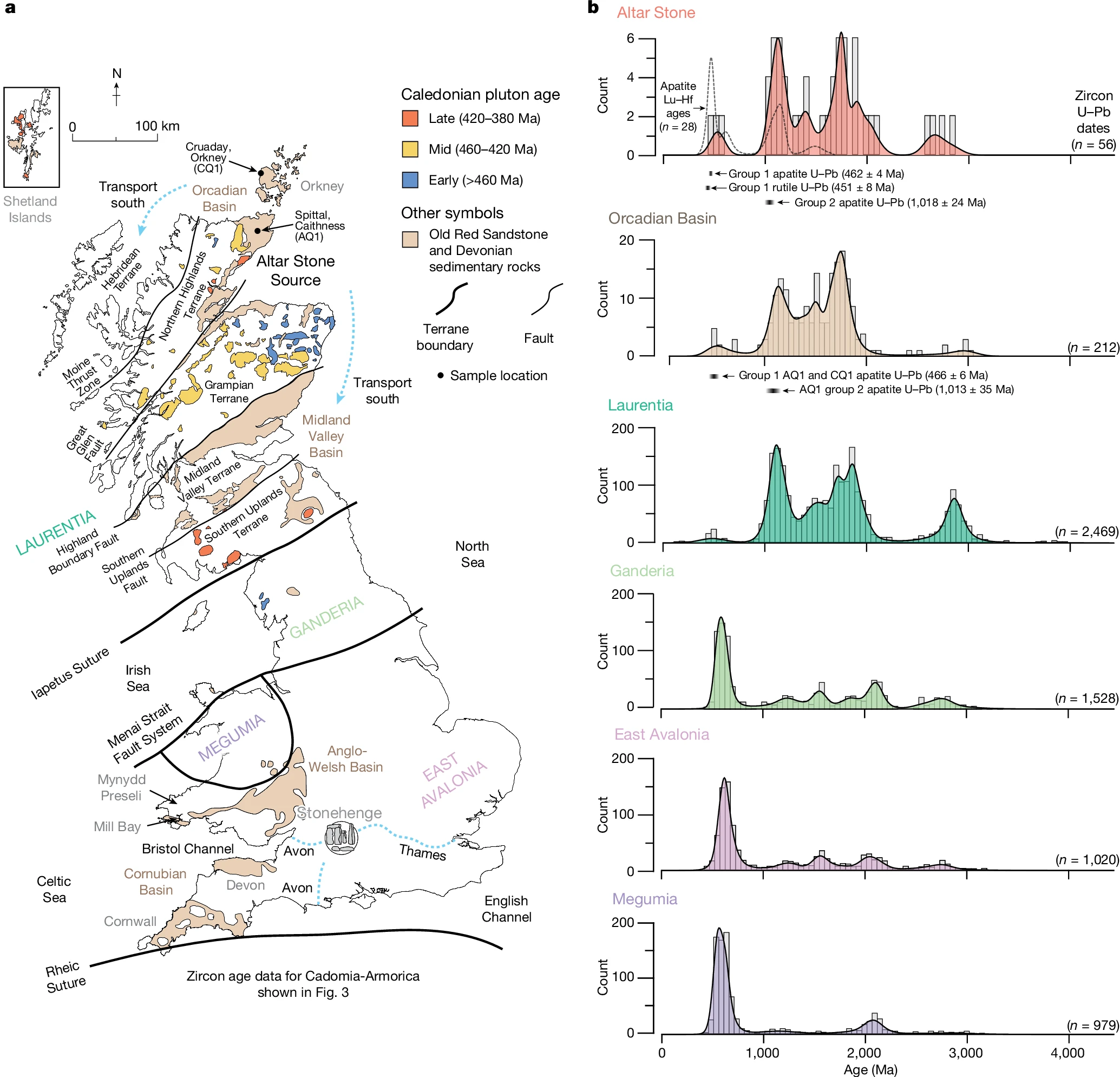
The origin of Stonehenge's Altar Stone must be in Laurentian terranes north of the Iapetus Suture (a major geological boundary separating northern Laurentian-derived rocks from southern Gondwanan ones) because the U-Pb ages in detrital minerals like zircon, apatite, and rutile show dominant Mesoproterozoic-Archaean peaks (e.g., ~1,047–1,790 Ma from Grenville, Labrador, and Gothian orogenies) with a mid-Ordovician overprint (~451–462 Ma from Grampian events), which are absent or mismatched south of this suture in regions like the Anglo-Welsh Basin or Dingle Peninsula. It cannot be from the Orkney Islands (Mainland Orkney) because petrographic and mineralogical analyses reveal mismatches, such as abundant detrital K-feldspar in Orkney Old Red Sandstone samples (versus very low in the Altar Stone), absent tosudite clay, and rare baryte cement (present in the Altar Stone). It cannot be from southwest Scotland (e.g., southwest Grampian Highlands or Midland Valley Basin) because, despite broad terrane similarities, statistical tests (Kolmogorov–Smirnov P < 0.05) show zircon U-Pb spectra mismatches (e.g., additional Devonian grains and fewer Archaean-Palaeoproterozoic ones), plus multi-proxy discrepancies in apatite trace elements, rutile ages, Pb isotopes, and petrography (e.g., more metamorphosed Dalradian sequences lacking the Altar Stone's unmetamorphosed, low-K-feldspar, baryte-cemented fabric). Therefore, it must be from the Orcadian Basin in northeast mainland Scotland, specifically areas like the Moray Firth to Caithness or John O'Groats, where the Mid-Devonian Old Red Sandstone matches all signatures as first-cycle detritus from Grampian sources.

Schematic map of Britain, showing outcrops of ORS and other Devonian sedimentary rocks, basement terranes and major faults. 
From: Clarke, A.J.I., Kirkland, C.L., Bevins, R.E. et al. A Scottish provenance for the Altar Stone of Stonehenge. Nature 632, 570–575 (2024). https://doi.org/10.1038/s41586-024-07652-1

See also: Richard E. Bevins, Nick J.G. Pearce, Stephen Hillier, Duncan Pirrie, Rob A. Ixer, Sergio Andò, Marta Barbarano, Matthew Power, Peter Turner, Was the Stonehenge Altar Stone from Orkney? Investigating the mineralogy and geochemistry of Orcadian Old Red sandstones and Neolithic circle monuments. Journal of Archaeological Science: Reports, 58, 104738 (2024). https://doi.org/10.1016/j.jasrep.2024.104738

Signature Type

Altar Stone Characteristics

Matching Source Characteristics

Pinpointing Explanation

Detrital Zircon U-Pb Ages

Concordant ages span 498–2,812 Ma; major peaks at 1,047 Ma, 1,091 Ma, 1,577 Ma, 1,663 Ma, and 1,790 Ma (dominated by Mesoproterozoic and Archaean components; no Carboniferous-Permian grains).

Statistically indistinguishable (Kolmogorov–Smirnov test P > 0.05) from Orcadian Basin Old Red Sandstone (ORS) samples (e.g., Spittal Quarry, Caithness; similar Mesoproterozoic peaks tied to Grenville (1,095–980 Ma), Labrador (1,690–1,590 Ma), and Gothian (1,660–1,520 Ma) orogenies).

Rules out Anglo-Welsh Basin (mid-Palaeozoic zircon maxima, P < 0.05) and New Red Sandstone (lacks Archaean-Mesoproterozoic); matches Laurentian terranes north of the Iapetus Suture, narrowing to Orcadian Basin due to first-cycle detritus from Grampian Terrane. Southwestern Scotland claim (e.g., Kokelaar) over-relies on broad terrane similarities but ignores statistical mismatches (P < 0.05) with Midland Valley Basin (central/southwest Scotland), which has additional Devonian zircons (~402 Ma) and fewer Archaean-Palaeoproterozoic grains; no southwestern samples fit the exact spectra.

Apatite U-Pb Ages

Two groups: Group 1 at 462 ± 4 Ma (mid-Ordovician, n=108); Group 2 at 1,018 ± 24 Ma (Grenville, n=9).

Orcadian Basin apatite: 473 ± 25 Ma and 466 ± 6 Ma (Ordovician), 1,013 ± 35 Ma (Grenville); overlaps within analytical uncertainty.

Ordovician ages reflect Grampian magmatism (466–443 Ma granitoids/gabbros); Grenville peak indicates Laurentian derivation; excludes southern Britain (Neoproterozoic-early Palaeozoic dominance) and Dingle Peninsula (ages <450 Ma). Southwestern sources lack the precise mid-Ordovician overprint and Grenvillian balance seen in Orcadian samples, further distinguishing from broader Grampian Terrane areas south of the Great Glen Fault.

Apatite Trace Elements

61% felsic (La/Nd <0.6, (La + Ce + Pr)/ÎŁREE <0.5, median Eu/Eu* = 0.59); 35% mafic-intermediate (La/Nd 0.5–1.5, (La + Ce + Pr)/ÎŁREE 0.5–0.7, median Eu/Eu* = 0.62); 4% alkaline (La/Nd >1.5, (La + Ce + Pr)/ÎŁREE >0.8, median Eu/Eu* = 0.45). Chondrite-normalised REE patterns show flat to negative gradients; mafic grains REE-enriched (up to 1.25 wt% ÎŁREEs).

Aligns with Grampian Terrane granitoids (felsic dominance) and Orcadian samples (similar REE profiles and principal component analysis discriminants like Nd and La).

Felsic-mafic mix indicates direct input from Grampian igneous sources; supports northeast Scottish provenance over Anglo-Welsh (different REE signatures and metamorphic overprints). Southwestern/central Scotland sediments show varied REE profiles due to different metamorphic histories and source mixing, not matching the Altar Stone's specific felsic-mafic ratio or REE enrichment.

Apatite Lu-Hf Ages

Ages at 1,496 Ma and 1,151 Ma (Laurentian); Group 1 at 470 ± 29 Ma (Ordovician).

Matches Orcadian Basin (e.g., 470 Ma overprint from Grampian events).

Reinforces Laurentian crust sourcing with mid-Ordovician metamorphic-magmatic overprint unique to regions north of Iapetus Suture. Southwestern claims ignore this overprint's specificity to northeastern basins, where Grampian events align more closely.

Rutile U-Pb Ages

Group 1 at 451 ± 8 Ma (mid-Ordovician, n=83); Group 2 Proterozoic (591–1,724 Ma, peak at 1,607 Ma, overlapping Labrador/Pinwarian orogenies).

Consistent with Laurentian orogenies in Orcadian Basin (Ordovician overprint from Grampian; Proterozoic peaks match basement terranes).

Ordovician group indicates Grampian influence; Proterozoic peak rules out southern Gondwanan terranes (Neoproterozoic rutile dominance); supports first-cycle detritus from northeast Scotland. Rutile signatures in southwestern Scotland include more variable Proterozoic peaks due to Dalradian metamorphism, not fitting the exact Labrador/Pinwarian dominance.

Pb Isotopes (207Pb/206Pb)

Apatite: 0.8603 ± 0.0033; Rutile: 0.8564 ± 0.0014 (initial ratios).

Matches Stacey-Kramers continental crust evolution model at 465 Ma (0.8601).

Consistent with evolved Laurentian crust north of Iapetus Suture; excludes less radiogenic southern British sources. Southwestern sources show similar but not identical ratios, diluted by local crustal variations not present in Orcadian Basin.

Mineral Composition & Petrography

Micaceous sandstone with baryte cement, calcite, clay minerals (including tosudite); very low K-feldspar; heavy mineral bands (zircon, rutile, apatite) with igneous textures (oscillatory zoning, no metamorphic overgrowths); absent marine fossils.

Orcadian Basin (non-Orkney): Low K-feldspar, presence of baryte and tosudite in some sequences; first-cycle magmatic detritus. Differs from Mainland Orkney ORS (abundant detrital K-feldspar in all samples, absent tosudite, baryte rare in only 2 samples).

Rules out Mainland Orkney (petrographic mismatches via X-ray diffraction, Raman, SEM-EDS); indicates continental fluvial-lacustrine deposition in other Orcadian areas (e.g., Moray Firth to John O'Groats); supports Mid-Devonian ORS with Grampian-derived sediments. Southwestern Grampian/Dalradian sequences are more metamorphosed (e.g., poly-deformed with garnets), lacking the unmetamorphosed, low-K-feldspar, baryte-cemented fabric; no exact petrographic match exists there.


The Brian John Boulder again

Photo: Dr Brian John

 We must thank Brian John for bringing this clast from Craig Rhos-y-felin to our attention:

In the words of 11 glacial geomorphologist:

1. If I had been doing a Reichelt shape classification I would have classed this as sub angular and typical of igneous clasts that have been dragged along the glacier bed.

2. I would say it has been glacially transported. That could account for the relatively smooth (abraded) surface and the other sub-angular surface and edges. There could even be some grooves on the abraded surface (upper image).

3. I would not be surprised if it is glacially transported. It looks to be the result of physical processes rather than chemkcal weathering. The light parts look hard and fresh and one side is flat. Corners and edges are neither sharp nor rounded. I could have picked it from a till in Bergen.

4. I am a bit less convinced. Looking at the right side of the first image the facets might be where cooling joints meet. That end is almost hexagonal. It is quite bullet-shaped though.

5. I would agree with my esteemed colleagues and say that there is certainly evidence for a possible faceted surface but difficult to say much more based on the photos.

6. In addition to the facets and chip marks that jumped out at first glance, the lower image to me has a slight bullet shape to it. Nothing definite from photos alone, and perhaps especially not from these two angles, but my very careful guess would agree with a subglacial transport path. Striae rarely preserve well (and on many lithologies don’t even form). Having said that, the clasts seem pretty weathered and battered.

7. Although quite hard to get a complete picture from just these two images, I’d say they seem to show a subrounded cobble/small boulder that is faceted, and has a shape that some people might say approaches a bullet-shape. I can also see some – what look like - chipmarks on some of its edges, the arrangement of which could indicate a responsible force from a single direction. From behind my wall of disclaimers and from within my cloud of speculation, I would probably guess that this boulder was subglacially transported. Striations on the faces would perhaps clinch it for me, but I could not see those in the images.

8. It's not possible to be definitive on the basis of these pictures alone. However, the presence of planar facets is consistent with subglacial transport. It would help if there were additional characters that might corroborate this, such as a stops-lee or double stoss-lee form. I guess there are no striations, or you would have mentioned them. Also rhyolite doesn't tend to striate.

9. My guess would be glacial. Not overly far travelled I’d say, but there does appear to be edge rounding and also chipping, with potential flat-iron faces. Looks like a lot of igneous clasts in tills in the north of Ireland.

10. I agree that this could be interpreted as subglacially transported boulder. Some rounding of the corners, but the facetted surface is not the best I have seen…if it has striations I would of course be 100% convinced.

11. Looks like a fluvioglacial clast. Definitely been in a fluvial system but only for short time as the degree of rounding is limited. The pic maybe misleading but I can see parallel lines -? Striations.

12. It looks partially faceted, edge rounded and abraded. The surfaces even appear to have some crude chattermarks/flip-outs. I cannot see any definitive striations but the lower image has an interesting set of linear marks that warrant a better image, though they may well be structural. I would say definitely glacially transported.

Sorry, the picture is of a clast at Craig Rhos-y-felin which hasn't been transported anywhere, the description is of the Newall Boulder. This is the "Brian John Boulder " described here:

Comparative Analysis of the "Brian John Boulder" at Craig Rhos-y-felin and the "Newall Boulder" from Stonehenge: Implications for the Origins and Transport of the Bluestones- a paper - DOI: 10.13140/RG.2.2.28445.01769

Here it is compared to the Newall Boulder, found at Stonehenge, also from Craig Rhos-y-felin having been manuported there by the neolithic builders  of the monument.


 The shaping of the Newall boulder has nothing to do with an imaginary ice flow.


Saturday, 10 January 2026

Correcting the Corrector: The Newall Boulder is Still Not Glacial

Brian John's latest self-published critique (preprint deposited on ResearchGate, January 2026), titled The Newall boulder at Stonehenge: correcting the “corrections”, sees him lurching forth once more like Monty Python's indefatigable Black Knight – "Tis but a flesh wound!" – swinging away despite the accumulating evidence. Written in a style that repeatedly invokes "the present author" with the regal detachment of a Victorian memoir (one is almost tempted to dub him "Princess Present Author" for the monarchical flair), it is a 13-page exercise in persistence, but persistence does not equal persuasion. His bombastic use of "refute", boldly declaring in the abstract that "The contents of the paper are therefore refuted", is equally baseless: a self-published assertion without decisive counter-evidence might contest, challenge, or question, but only an egotist would claim outright refutation when even he concludes the debate remains "scientifically disputed". It recycles familiar claims while misrepresenting our peer-reviewed paper (Bevins et al., 2025, Journal of Archaeological Science: Reports 66: 105303), which presents new petrographic, automated SEM-EDS mineral mapping, portable XRF geochemical data, and contextual analysis to reaffirm the boulder's origin at Craig Rhos-y-Felin and dismiss glacial transport.

The piece opens with the now-familiar falsehood: our manuscript was supposedly "rejected by the Journal of Quaternary Science" before acceptance elsewhere. As previously noted, no such rejection occurred; it was submitted directly to JAS:Reports, the appropriate geoarchaeological venue, and passed standard peer review. This invention sets the tone for the rest – assertions dressed as fact, selective omissions, and a heavy reliance on blog posts as "evidence".

Here are the main points addressed systematically:

1. Provenance to Craig Rhos-y-Felin (Sections 3–4)

John claims "no convincing evidence" for a Rhos-y-Felin source, citing insufficient sampling density, no identical matches, reliance on old museum fragments, and potential mislabelling. He insists we must demonstrate that all nearby foliated rhyolite outcrops are "substantially different".

Response: Our study builds on 15+ years of cumulative work (e.g., Bevins et al. series from 2011 onward), incorporating new analyses of previously unsampled areas on the boulder. Key immobile elements (Zr, Nb, Th), mineral assemblages (foliation, spherulites, quartz phenocrysts), and textural features show strong convergence with Rhos-y-Felin rhyolite Group C. Provenancing in igneous terrains uses probabilistic multi-method matches, not identical twins across every metre – a standard approach the John ignores (cf. comparable studies on dolerites or the Altar Stone). Museum fragments are contextualised with fresh field sampling; mislabelling risks are acknowledged but do not invalidate the overall dataset. The demand for exhaustive exclusion of every nearby outcrop is unrealistic and not required in geoarchaeology.

2. Morphology and "Glacial" Features (Sections 5–6)


His Fig. 1 photo is annotated with labels such as "Fresh rock exposed in fracture scars", "Eroded facet", "Slickenside surface with quartz crystals and lineations", and "Weathered 'top' surface". He insists these are "strong indicators of glacial transport", apparently supported by a poll of 11/12 unnamed "senior geomorphologists".

Response: These features – variable facets, edge rounding, localised lineations, and fresh scars – are consistent with natural jointing in the rhyolite, prolonged surface weathering exploiting discontinuities, and human-induced breakage/percussion (e.g., small scars near the tip matching debitage from monolith shaping). Subglacial abrasion produces more uniform striae, polish, and faceting; we see none of that. The "expert poll" (non-blind, photo-based, unpublished) lacks methodological rigour – photo interpretation of geomorphology is notoriously subjective. Our high-resolution imaging and comparison to Rhos-y-Felin debitage/monolith fragments support breakage from Stone 32d (the stump), not ice transport. Senior geomorphologist input on our team (e.g., Scourse) finds no compelling glacial signature.

3. Glacial Transport and Ice Limits (Section 6)

BJ argues Bristol Channel erratics prove inland reach to Salisbury Plain, dismisses ice-rafting claims, and invokes pre-Devensian (Anglian/Wolstonian) speculation despite "abundant evidence".

Response: Far-travelled erratics in the Bristol Channel relate to coastal/rafting or limited Devensian advances – not inland chalkland penetration. BRITICE-CHRONO models and recent work (Scourse, 2024) constrain LGM limits well west/north; no ground-truthed glacial deposits (till, striated bedrock, classic erratics) exist on Salisbury Plain. Pre-Devensian ice lacks supporting stratigraphy or dating here. The boulder's context (Neolithic layers, fresh fractures) fits human debitage far better.

4. Broader Bluestone Assemblage (Sections 7–9)

John then claims 46+ lithologies prove erratic scatter, accuses bias (ignoring hammerstones/etc.), and insists most are unmodified erratics/"rubbish stones".

Response: Our focus is on monoliths and associated debitage (the monument's core). Variability is constrained to ~12–15 Preseli lithologies with multi-source origins – not random glacial randomness. "Rubbish" reflects selection/breakage processes. Claims of 12–15 "quarries" misrepresent; we identify specific extraction sites (Rhos-y-Felin, Carn Goedog) supported by excavation (Parker Pearson et al., 2019+), while the John's blog critiques lack new fieldwork.

5. Local Opportunistic Use in Wales (Section 9)

He further cites Bedd yr Afanc as evidence of local, opportunistic stone use without significance.

Response: This supports our view – Preseli stones were abundant locally and used where convenient. It does not undermine targeted selection/transport for Stonehenge.

6. Press and "Pseudo-Science" (Final sections)

The shy and retiring Brian John criticises the Aberystwyth release/media as "over-sold". We agree media can sensationalise; our paper is measured, data-led, and corrects prior errors (especially in John's 2024 piece). It adds substantial new analyses – hardly "little new information".

In summary, the Newall boulder is rhyolite debitage from Craig Rhos-y-Felin, transported by Neolithic people – not a glacial erratic. The data overwhelmingly support human transport; the glacial hypothesis lacks any credible foundation, relying on special pleading to ignore the vast moraine of counter-evidence and an unsavoury dismissal of Neolithic ingenuity and persistence simply because they are from a previous time.

Full references and data are in Bevins et al. (2025).

Thursday, 8 January 2026

A Critical Review of Peter Kokelaar's Hypothesis on Glacial Contributions to the Stonehenge Bluestones

Peter Kokelaar, a retired volcanologist and field geologist with extensive experience in the Quaternary history of the Gower Peninsula, has made a thoughtful and detailed contribution to the long-running debate over the transport of Stonehenge’s bluestones. In two online articles, Towards Stonehenge: the Anglian Glaciation of Gower and Stonehengehe argues that glacial processes, specifically the Anglian-stage Irish Sea Ice Stream (c. 450,000 years ago), played a major role in moving bluestones from their Pembrokeshire sources at least part of the way towards Salisbury Plain. While acknowledging the absence of direct proof, Kokelaar proposes that ice performed “most of the work,” depositing stones “near enough” for later Neolithic collection and incorporation into the monument. His work is richly illustrated with high-quality photographs, maps, and LiDAR imagery, reflecting sustained and meticulous field observation.

Kokelaar’s contributions deserve serious attention, particularly for their geological rigour on Gower, where he documents compelling evidence of Anglian ice overriding the peninsula, transporting far-travelled erratics, and reshaping landscapes in ways that have often been under-appreciated or misattributed to later glaciations. His work strengthens understanding of the southern reach and dynamic behaviour of the Irish Sea Ice Stream. At the same time, when these regional observations are extrapolated to Stonehenge itself, the hypothesis encounters substantial difficulties. By early 2026, the prevailing multidisciplinary consensus, drawing on geological provenancing, archaeological excavation, and Quaternary geomorphology, overwhelmingly favours deliberate Neolithic human transport from specific Preseli outcrops, with no compelling evidence for glacial delivery to the Salisbury Plain region.


Core Arguments and Their Limitations

Kokelaar’s case rests on several interconnected claims, primarily grounded in his observations on Gower and projected eastward.

Ice Flow Trajectory and Transport Capability

Kokelaar anchors his hypothesis in detailed geological observations from the Gower Peninsula, which he interprets as evidence that Anglian ice carried Pembrokeshire-derived material eastward in a direction broadly aligned towards Stonehenge. Gower provides one of the most southerly and best-exposed records of Irish Sea Ice Stream activity, and Kokelaar documents this record with considerable care.

A central line of evidence is the diverse assemblage of far-travelled erratics preserved on Gower beaches, many reworked from Anglian deposits. Kokelaar records more than twenty igneous lithologies, including gabbros consistent with St David’s Head, silicic volcanic rocks comparable to Ramsey Island, and non-spotted dolerites matching Pembrokeshire sources. Particularly significant are erratics of riebeckite microgranite derived from Ailsa Craig in western Scotland, a well-established tracer of Irish Sea Ice Stream transport. These lithologies collectively confirm long-distance entrainment, southward flow through the Irish Sea basin, and subsequent east–southeast deflection across Gower into the Bristol Channel.

Ice-flow direction is further constrained by mapped erratic dispersal patterns and geomorphological indicators. Kokelaar’s reconstructions (for example, his Figure 12) depict ice advancing from the west-northwest across Gower, a trajectory that in broad compass terms points towards southern Britain. Supporting evidence includes marine shells incorporated within till at sites such as Cockle Pot, interpreted as material entrained from Carmarthen Bay and redistributed by advancing ice. Together, these observations demonstrate that Anglian ice on Gower was thick, coherent, and dynamically capable of transporting lithologies over considerable distances.

Kokelaar also emphasises subglacial and erosional features indicative of warm-based ice overriding a karst landscape. Cave systems such as Ogof New Park exhibit sediment infill, constricted passages, and mixed corrosion features plausibly interpreted as subglacial modification. At the surface, bedrock-incised channels (for example at Melins Lake), rounded coastal cliffs, and large fluvioglacial boulders at Pwll-du point to vigorous erosion and meltwater activity during deglaciation. Fossil material associated with some Pwll-du deposits has been dated to around 425,000 years ago, consistent with an Anglian age. More broadly, Kokelaar argues that Anglian ice overrode a pre-existing marine platform on Gower, substantially modifying landforms often attributed to later (Devensian) glaciation.

These observations convincingly establish the power and reach of Anglian ice on Gower. The difficulty arises when this evidence is extended beyond the Bristol Channel.

Critique:
While regional ice-flow alignment shows that ice moved eastward across Gower, this does not in itself demonstrate penetration onto Salisbury Plain. Most glaciological reconstructions constrain the Anglian southern margin to the Bristol Channel and adjacent lowlands, with higher ground promoting thinning, stagnation, or deflection rather than sustained eastward advance. Crucially, the geomorphological and sedimentary signatures so clearly preserved on Gower, tills, erratic spreads, and subglacial erosion, are absent from Salisbury Plain and its margins, despite extensive Quaternary mapping and repeated archaeological exposure.


The Mendip Hills as a Critical Constraint

A major obstacle to Kokelaar’s mapped ice trajectory is the Mendip Hills, which occupy a key topographic position between the Bristol Channel and Salisbury Plain and are explicitly crossed by ice in his reconstructions. In mainstream Quaternary geology, however, the Mendips lie outside the direct influence of Pleistocene ice sheets, including the Anglian glaciation.

The Mendip plateau and slopes are mantled by extensive periglacial deposits, commonly termed head, rubby drift, or plateau drift, comprising angular rubble derived almost entirely from local Carboniferous limestone and adjacent bedrock. These deposits are classic products of freeze–thaw weathering and solifluction and lack the sorting, matrix support, or lithological diversity characteristic of glacial till. No confirmed far-travelled erratics from Wales, Ireland, or Scotland—and notably no Preseli-type spotted dolerite—have been recorded on the Mendip plateau or higher ground.

There is good evidence that Irish Sea ice entered the Bristol Channel during the Anglian, depositing exotic erratics on low-lying coastal sites and islands such as Flat Holm and Steep Holm, and leaving patchy tills in the Somerset lowlands. These occurrences demonstrate ice proximity, but they also underscore a consistent pattern: far-travelled material is confined to low elevations, while the hills themselves remain unaffected. Mendip landforms—gorges, dolines, dry valleys, and cave systems—are overwhelmingly attributed to karst and periglacial processes rather than ice overriding.

The Mendips rise to approximately 325 metres above sea level. For ice to have crossed the plateau, local ice thickness would need to have exceeded this elevation by a substantial margin. While continental ice sheets can certainly override relief of this scale, conditions at the southern margin of the Irish Sea Ice Stream were likely far more marginal. Kokelaar himself estimates ice thicknesses of only around 250–300 metres over low-lying Gower. Under such conditions, ice would be expected to thin rapidly against rising terrain and deflect around uplands rather than override them. The complete absence of glacial deposits or erratics on the Mendips strongly suggests that they acted as a partial barrier, diverting ice into the Somerset lowlands and along the Bristol Channel rather than permitting direct eastward flow towards Salisbury Plain.


Contrasting Gower and the Mendips

The contrast between Gower and the Mendips highlights a key methodological issue. Gower lay directly in the path of the Irish Sea Ice Stream, at low elevation and with lithologies conducive to both erosion and preservation of glacial deposits. The Mendips formed an elevated limestone massif at or beyond the effective ice margin, dominated by karstic drainage and periglacial reworking. Gower shows what Anglian ice does to landscapes it clearly overrides; the Mendips show what landscapes look like when it does not. Robust evidence from the former cannot be linearly projected across the latter without contradicting well-established geomorphological constraints.


Bluestone Morphologies and Assemblage

Kokelaar argues that the Stonehenge bluestones comprise a mixture of angular pillars and rounded, abraded forms suggestive of glacial transport. He points to stones such as the Newall and Boles Barrow boulders as potential erratics and interprets widespread debitage as evidence of a natural glacial supply gradually exhausted by builders.

Critique:

Polyhedral and pillar-like forms are readily explained by natural jointing in Preseli dolerite sills, which facilitated Neolithic quarrying with minimal shaping. Apparent surface rounding or smoothing does not, in itself, demonstrate glacial transport. In the Preseli source area, many dolerite and rhyolite blocks occur naturally as detached or partially weathered pillars and boulders with softened edges, produced by long-term chemical weathering, joint-controlled block release, and limited fluvial reworking prior to the Anglian glaciation. As a result, stones may acquire rounded or smoothed profiles in situ, before any human or glacial movement. Similar morphologies are observed at quarry sites such as Carn Goedog and Craig Rhos-y-felin, where blocks detached from outcrops already display a range of angular to moderately rounded forms. Consequently, stone shape alone cannot be taken as diagnostic of glacial transport, particularly in the absence of unequivocal subglacial features such as faceting, striations, or percussion marks. 

Detailed analyses of the Newall boulder, a foliated rhyolite excavated in 1924, demonstrate that it lacks subglacial faceting or striations and matches material quarried at Craig Rhos-y-felin. Its surface alterations are best explained by post-depositional weathering rather than ice modification. Similarly, the Boles Barrow boulder has a highly disputed provenance and context; Mike Pitts has described the archaeology of Boles Barrow as "a mess," noting significant uncertainties over whether the specimen in Salisbury Museum originated from a primary Neolithic deposit in the barrow, rendering it far from an "unequivocal erratic". Debitage patterns at Stonehenge reflect phased on-site dressing, reuse, and reworking over centuries, not dispersed glacial moraine.


Source Specificity and the Nunatak Hypothesis

The dominance of spotted dolerite from specific eastern Preseli outcrops poses a further problem for glacial models. Kokelaar suggests that these outcrops protruded as nunataks, enabling selective supraglacial transport.

Critique:
While partial nunatak exposure is plausible, no evidence supports the transport of megalith-sized blocks over 200 km supraglacially in sufficient numbers and lithological purity to account for the Stonehenge assemblage. The complete absence of spotted dolerite erratics beyond Preseli—despite extensive surveys—remains a critical weakness for any glacial explanation.


Archaeological Evidence for Human Transport

Kokelaar questions the interpretation of Neolithic quarries at Carn Goedog and Craig Rhos-y-felin and emphasises the absence of preserved transport routes.

Critique:

Excavations have revealed extraction platforms, removal scars, stone tools, loading features, and radiocarbon dates around 3400–3000 BC, consistent with Stonehenge’s early phases. Geochemical provenance is precise and non-random. While transport logistics remain debated, human movement of large stones over long distances is well attested in Neolithic Britain and fits the cultural context of monumentality and interregional connection.


Claims Regarding the Altar Stone

Kokelaar extends his glacial perspective to the Altar Stone (Stone 80), accepting its Scottish provenance but challenging the northeastern constraint proposed in recent studies. He argues that detrital zircon U-Pb age spectra, central to the 2024 identification, could equally match sediments from southwest or central Scotland (southwest of the Great Glen Fault), derived from erosion of Grampian Highland rocks. This broader sourcing, he suggests, aligns better with Anglian Irish Sea Ice Stream transport of Scottish material southward. This interpretation, while highlighting potential overlaps in zircon inheritance, is selective: it engages only with zircon data and overlooks the multi-proxy evidence (including apatite and rutile trace-element chemistry, mineral fabrics, and stratigraphic context) that robustly constrains the Altar Stone to Old Red Sandstone of the Orcadian Basin in northeast Scotland.


Conclusion

Peter Kokelaar’s articles represent a serious and informed challenge from an independent geologist deeply familiar with the Quaternary history of southwest Wales. His work on Gower significantly enriches understanding of Anglian glaciation and rightly cautions against dismissing natural processes in favour of purely anthropogenic explanations. However, the extension of this regional evidence to Stonehenge involves substantial extrapolation across terrain, most notably the Mendip Hills, that shows no trace of glacial overriding. The hybrid model, in which ice performs “most of the work” before depositing stones “near enough,” relies on assumptions that remain difficult to test and unsupported by positive evidence.

In contrast, the human-transport model is underpinned by targeted quarry archaeology, precise provenance matching, and a coherent cultural framework. Kokelaar’s revival of the glacial hypothesis remains an intriguing and valuable provocation, but one that does not displace the accumulated multidisciplinary evidence favouring deliberate Neolithic transport of the bluestones to Stonehenge.

References

  • Bevins, R., Ixer, R. A., Pearce, N., Scourse, J., & Daw, T. (2023). Lithological description and provenancing of a collection of bluestones from excavations at Stonehenge by William Hawley in 1924 with implications for the human versus ice transport debate of the monument’s bluestone megaliths. Geoarchaeology: An International Journal, 38(6), 771-785. https://doi.org/10.1002/gea.21971
  • Richard E. Bevins, Nick J.G. Pearce, Rob A. Ixer, James Scourse, Tim Daw, Mike Parker Pearson, Mike Pitts, David Field, Duncan Pirrie, Ian Saunders, Matthew Power. The enigmatic ‘Newall boulder’ excavated at Stonehenge in 1924: New data and correcting the record. Journal of Archaeological Science: Reports,Volume 66, 2025, 105303, ISSN 2352-409X, https://doi.org/10.1016/j.jasrep.2025.105303 (https://www.sciencedirect.com/science/article/pii/S2352409X25003360)
  • Kokelaar, P. (n.d.-a). Towards Stonehenge: the Anglian glaciation of Gower. Retrieved January 8, 2026, from https://kokelaargower.com/towards-stonehenge-the-anglian-glaciation-of-gower/
  • Kokelaar, P. (n.d.-b). Stonehenge. Retrieved January 8, 2026, from https://kokelaargower.com/stonehenge/ 
  • Pearson, Mike Parker, Josh Pollard, Colin Richards, Kate Welham, Chris Casswell, Charles French, and others, ‘Megalith Quarries for Stonehenge’s Bluestones’, Antiquity, 93 (2019), 45–62 http://dx.doi.org/10.15184/aqy.2018.111
  • Scourse, J.D. (1997). Transport of the Stonehenge bluestones: Testing the glacial hypothesis. In B. Cunliffe & C. Renfrew (Eds.), Science and Stonehenge (Proceedings of the British Academy 92, pp. 271–314). Oxford University Press.
  • Thorpe, R.S., Williams-Thorpe, O., Jenkins, D.G., & Watson, J.S. (1991). The geological sources of the Stonehenge bluestones. Oxford Journal of Archaeology, 10(2), 127–148.