I liked you post about Adam's Grave and it put my in mind of going to Stoney Littleton yesterday, as the weather forecast was promising.
It didn't disappoint.
I attach a few photos.
It was 1 deg C outside but more like 8 or 9 deg C inside the passage, with lots of water dripping in from recent snow/rain and very high overall humidity.
Not great for the camera, but it survived.
Being confined, damp and dark it reminded me of caving in the Mendips in my youth.
Stoney Littleton is interesting as the 4 or 5 degree slope means the sun doesn't rise over the horizon until about 45 minutes after proper sunrise.
Unlike Maes Howe or Newgrange, you can get to see it without booking or company.
I hope this solar alignment business isn't catching !
Click to enlarge. Photos (c) Stephen Cogbill
For more on the alignment see Silent Earth and Terence Meaden.
Highways England will continue archaeological surveys in the new year as part of the ongoing scheme to improve journeys for people using the A303 at Stonehenge. The survey work, which includes surface artefact collection, topsoil tests and trial trenching, is part of the company’s continuing commitment to preserving the World Heritage Site and in particular its Outstanding Universal Value. Highways England Project Director Derek Parody said: “Heritage is very much at the heart of our work at Stonehenge. “As well as removing the traffic bottleneck at Stonehenge and addressing the rat-running issue through local villages, the proposed scheme will remove the sight and sound of traffic from the iconic monument and reduce intrusion in the wider World Heritage Site landscape. “The environmental, archaeological and geophysical surveys we have been carrying out since 2016, and our review of existing surveys, have added to our knowledge and understanding of this unique landscape and helped us develop the design of our preferred route. “Our continuing archaeological survey work, which we are carrying out with experts in the field, will ensure we gather vital information about the environment and archaeology to inform the project as it progresses.” Among the experts is the Stonehenge Scientific Committee, a body of leading independent archaeologists, who have advised on the ongoing survey work, and will continue to do so as the company develops the details of the scheme. The preferred route for the £1.6 billion A303 upgrade between Amesbury and Berwick Down was announced in September. It includes a free-flowing dual carriageway with a tunnel at least 1.8 miles long and a much-needed bypass north of Winterbourne Stoke. Following public consultation earlier in the year and further engagement with local communities, heritage groups, archaeologists, historians and engineers, the preferred route was chosen so that the route now closely follows the existing A303 through the World Heritage Site. This alignment avoids important archaeological sites and intrusion on the view of the setting sun from Stonehenge during the winter solstice. The Government, as part of its £15 billion road strategy, is committed to upgrading all remaining sections of the A303 between the M3 and M5 to a high quality dual carriageway standard, starting with three schemes: one at Stonehenge, one between Sparkford and Ilchester and the third on the A358 between the M5 at Taunton and the A303 Southfields Roundabout. Highways England plans to hold a statutory public consultation in early 2018, and in the meantime, details of the preferred route are available on the scheme webpage: www.highwaysengland.citizenspace.com/cip/a303-stonehenge/
During the last glaciation, most of the British Isles and the surrounding continental shelf were covered by the BIIS (for overviews see Chiverrell & Thomas 2010; Clark et al. 2012). To assist investigation of the extent and geometry of the former ice sheet covering Britain, the BRITICE project tackled the compilation and open data issues by reading relevant publications and assessing, collating and digitizing the described evidence-base of glacial landforms to create a publication reporting the methods (Clark et al. 2004), including a printed Glacial Map of Britain (at a scale of 1:625 000) and an accompanying freely available GIS geodatabase with >20 000 features (available from https://www.sheffield.ac.uk/geography/staff/clark_chris/britice). The compiled evidence was reviewed in Evans et al. (1995). The BRITICE V.1 map and these publications have been widely accessed and used by the scientific community, the education sector and the general public, with over 25 000 downloads from the website up to December 2016. The GIS files have been used to compare with results from numerical ice-sheet modelling (Hubbard et al. 2009; Patton et al. 2013). A number of important developments, since the production of the original version, have highlighted its shortcomings and motivated us to fully revise the database to produce BRITICE version 2.
The notable feature of the ice map for the Stonehenge region is that there are no features. No moraines, no glaciers and no glacial erratics.
Dr John's link has done us all a favour in driving the final nail in to the coffin lid of the glacial transport theory for the bluestones at Stonehenge.
As Scourse writes: "The common element which unifies all advocates of the glacial hypothesis is incredulity that these stones could have been transported from Pembrokeshire to Wiltshire by prehistoric man." Once you accept that neolithic man could move monoliths a few yards then accepting that they could transporting them down the A40 from Wales to Gloucester and then down the A417 to the Marlborough Downs is just "haggling over the price"
This summer, the University of Reading Archaeology Field School excavated one of the most extraordinary sites we have ever had the pleasure of investigating. The site is an Early Neolithic long barrow known as “Cat’s Brain” and is likely to date to around 3,800BC. It lies in the heart of the lush Vale of Pewsey in Wiltshire, UK, halfway between the iconic monuments of Stonehenge and Avebury.
It has long been assumed that Neolithic long barrows are funerary monuments; often described as “houses of the dead” due to their similarity in shape to long houses. But the limited evidence for human remains from many of these monuments calls this interpretation into question, and suggests that there is still much to be learnt about them.
In fact, by referring to them as long barrows we may well be missing the main point. To illustrate this, our excavations at Cat’s Brain failed to find any human remains, and instead of a tomb they revealed a timber hall, suggesting that it was very much a “house for the living”. This provides an interesting opportunity to rethink these famous monuments.
The timber hall at Cat’s Brain was surprisingly large, measuring almost 20 metres long and ten metres wide at the front. It was built using posts and beamslots, and some of these timbers were colossal with deep cut foundation trenches, so that it’s general appearance is of a robust building with space for considerable numbers of people. The beamslots along the front of the building are substantially deeper than the others, suggesting that its frontage may have been impressively large, monumental in fact, and a break halfway along this line indicates the entrance way.
An ancient ‘House Lannister’?
Timber halls such as these are an aspect of the earliest stages of the Neolithic period in Britain, and there seems little doubt that they were created by early pioneer Neolithic people. Frequently, they appear to have lasted only two or three generations before being deliberately destroyed or abandoned. These houses need not be dwellings, however, and given their size could have acted as large communal gathering places.
It is worth briefly pausing here and thinking of the image of a house – for the word “house” is often used as a metaphor for a wider social group (think of the House of York or Windsor, or – if you’re a Game of Thrones fan like me – House Lannister or House Tyrell).
In this sense, these large timber halls could symbolise a collective identity, and their construction a mechanism through which the pioneering community first established that identity. We may imagine a variety of functions for this building, too, none of which are mutually exclusive: ceremonial houses or dwellings for the ancestors, for example, or storehouses for sacred heirlooms.
From this perspective, it is not a huge leap of the imagination to see them as containing, among other things, human remains. This does not make them funerary monuments, any more than churches represent funerary monuments to our community. They were not set apart and divided from buildings for the living, but represented a combination of the two – houses of the living in a world saturated with, and inseparable from, the ancestors.
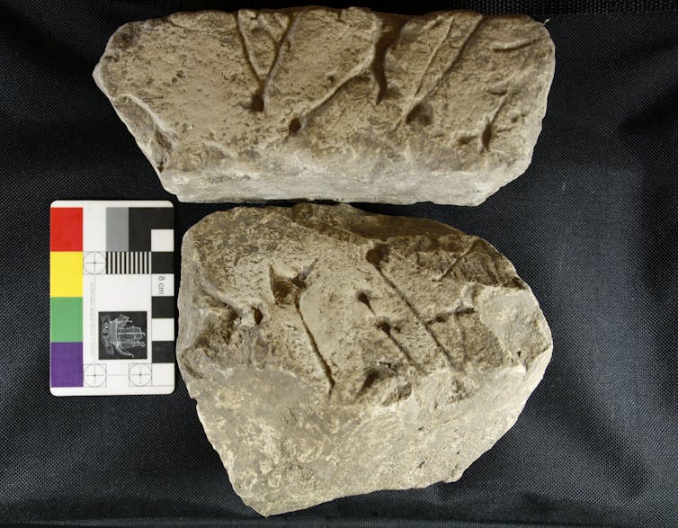
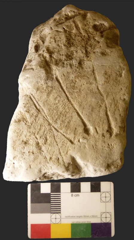
These houses would have been replete with symbolism and meaning, and charged with spiritual energy; even the process of building them is likely to have taken on profound significance. In this light, then, it is interesting to note that towards the end of our excavations this summer, just as we were winding up, we uncovered two decorated chalk blocks that had been deposited into a posthole during the construction of the timber hall.
The decoration on these blocks comprises deliberately created depressions and incised lines, which have wider parallels at other early Neolithic sites, such as the flint mines of Sussex.
The marked chalk blocks. University of Reading, Author provided
Controversy often surrounds decorated chalk pieces; chalk is soft and easily marked and some people suggest that they are “decorated” with nothing more than the scratchings of badgers. But there is no doubt that the Cat’s Brain marks are human workmanship and the discovery should spark a fresh investigation into decorated chalk plaques more widely.
Imbued with power
For the moment, the original purpose of the carvings remains obscure, but clearly they were of significance. They will have had meaning and potency to the people that created them, and by depositing them in a posthole the building itself may have been imbued with that power, as well as marking it with individual or community identity. The discovery adds to the way we understand these monuments and weight to the argument that these buildings represent more than just “houses of the dead”.
Over time, deep ditches were dug either side of the timber hall at Cat’s Brain and the quarried chalk may have been piled over the crumbling building after it had gone out of use, closing it down and transforming the house from a wooden structure into a permanent earthen monument; the shape and symbolism of which will have been known to all who saw it. With this transformation, the identity of this early Neolithic group was finally and permanently inscribed upon the landscape.
Now, with this investigation, we have been granted a glimpse of the lives and beliefs of our ancestors nearly 6,000 years ago.
The excavations at Cat’s Brain, including the decorated chalk blocks, will feature on Digging for Britain, to be screened on BBC4, at 9pm on Wednesday November 22.
Mr. Cunnington F.G.S. next read a paper on " the Geology of the Stones of Stonehenge," in which he first pointed out the many erroneous statements which had been made on this subject, some having described the stones as foreign marble resembling that -of Carrara; others as formed of artificial matter, moulded to the original forms; and others again as a species of coarse freestone. These various statements having been satisfactorily refuted, he proceeded to explain that the outer circle and the large Trilithons at Stonehenge as well as the whole of the circles at Avebury, were composed of sarsen stones : the sarsens found so abundantly in Wiltshire, more especially in the Clatford valley of North Wilts, being the remains of sandy strata once lying above the chalk, the softer portions of which have been washed away, leaving these rocky masses on the surface. He then referred to the smaller circle and inner oval, and pronounced all these stones to be primary igneous rocks and of foreign origin, the altar stone is a fine-grained micaceous sandstone. From the facts adduced, Mr. Cunnington argued that Stonehenge was not originally erected either as a sepulchral monument, or as an astronomical calendar. This paper will however be found in extenso in the Magazine, and need not therefore be anticipated here.
In the Society’s copy of WAM Volume X there is a marginal note in pencil next to the final sentence “The paper will be found in extenso in the Magazine, and need not therefore be anticipated here.” Someone has written “Where?”
Where indeed, as I haven't found it yet, and many thanks to James Kay -Library and Archive Volunteer of WANHS for checking and finding the note.


 The excavations at Cat’s Brain, including the decorated chalk blocks, will feature on Digging for Britain, to be screened on BBC4, at 9pm on Wednesday November 22.